
Fai una donazione
Preparati per la tua prossima avventura:
In qualità di associato Amazon, questo sito riceve una commissione sugli acquisti idonei senza alcun costo aggiuntivo per te.
Mappa topografica Basingstoke
Clicca sulla mappa per visualizzare l'altitudine.
Fai una donazione
Preparati per la tua prossima avventura:
In qualità di associato Amazon, questo sito riceve una commissione sugli acquisti idonei senza alcun costo aggiuntivo per te.
Basingstoke
Situated in a valley through the Hampshire Downs at an average elevation of 88 metres (289 ft) Basingstoke is a major interchange between Reading, Newbury, Andover, Winchester, and Alton, and lies on the natural trade route between the southwest of England and London. The area had been something of an interchange even in ancient times. It had been cut by a Roman roadway that ran from northeast to southwest, from Silchester towards Salisbury (Sorbiodunum), and by another Roman road that linked Silchester (Calleva Atrebatum) in the north with Winchester (Venta Belgarum) to the south. These cross-cutting highways, along with the good agricultural land hereabouts, account for the many "Roman" villas in the area, mostly put up by Romanized native nobility (Roman villa). Even more ancient was the Harrow Way, a Neolithic trackway, possibly associated with the ancient tin trade, that crossed all of southern England from west to east, from Cornwall to Kent, passing right through Andover and Basingstoke.
Fai una donazione
Preparati per la tua prossima avventura:
In qualità di associato Amazon, questo sito riceve una commissione sugli acquisti idonei senza alcun costo aggiuntivo per te.
A proposito di questa mappa
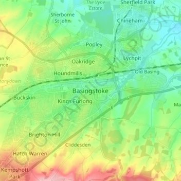
Nome: Mappa topografica Basingstoke, altitudine, rilievo.
Altitudine media: 107 m
Altitudine minima: 59 m
Altitudine massima: 206 m
Fai una donazione
Preparati per la tua prossima avventura:
In qualità di associato Amazon, questo sito riceve una commissione sugli acquisti idonei senza alcun costo aggiuntivo per te.
Altre mappe topografiche
Clicca su una mappa per visualizzarne la topografia, l'altitudine e il rilievo.
Winterhill Plantation
United Kingdom > England > Hampshire > Basingstoke and Deane > Whitchurch > Wells-In-The-Field
Altitudine media: 100 m
Basingstoke
United Kingdom > England > Hampshire > Basingstoke and Deane
Situated in a valley through the Hampshire Downs at an average elevation of 88 metres (289 ft) Basingstoke is a major interchange between Reading, Newbury, Andover, Winchester, and Alton, and lies on the natural trade route between the southwest of England and London. The area had been something of an…
Altitudine media: 109 m
Fai una donazione
Preparati per la tua prossima avventura:
In qualità di associato Amazon, questo sito riceve una commissione sugli acquisti idonei senza alcun costo aggiuntivo per te.
Morgaston Wood
United Kingdom > England > Hampshire > Basingstoke and Deane > Sherborne St John
Altitudine media: 76 m
Mortimer West End
United Kingdom > England > Hampshire > Basingstoke and Deane > Mortimer West End
Altitudine media: 90 m
Fai una donazione
Preparati per la tua prossima avventura:
In qualità di associato Amazon, questo sito riceve una commissione sugli acquisti idonei senza alcun costo aggiuntivo per te.
Wootton St. Lawrence
United Kingdom > England > Hampshire > Basingstoke and Deane
Altitudine media: 115 m
Fai una donazione
Preparati per la tua prossima avventura:
In qualità di associato Amazon, questo sito riceve una commissione sugli acquisti idonei senza alcun costo aggiuntivo per te.
Newtown
United Kingdom > England > Hampshire > Basingstoke and Deane > Newtown
Altitudine media: 109 m
Sherborne St. John
United Kingdom > England > Hampshire > Basingstoke and Deane > Sherborne St John
Altitudine media: 79 m
Fai una donazione
Preparati per la tua prossima avventura:
In qualità di associato Amazon, questo sito riceve una commissione sugli acquisti idonei senza alcun costo aggiuntivo per te.
Bramley Corner
United Kingdom > England > Hampshire > Basingstoke and Deane > Bramley
Altitudine media: 69 m
Fai una donazione
Preparati per la tua prossima avventura:
In qualità di associato Amazon, questo sito riceve una commissione sugli acquisti idonei senza alcun costo aggiuntivo per te.
Sherfield on Loddon
United Kingdom > England > Hampshire > Basingstoke and Deane
Altitudine media: 66 m
Monk Sherborne
United Kingdom > England > Hampshire > Basingstoke and Deane > Monk Sherborne
Altitudine media: 107 m
Fai una donazione
Preparati per la tua prossima avventura:
In qualità di associato Amazon, questo sito riceve una commissione sugli acquisti idonei senza alcun costo aggiuntivo per te.
Kingsclere
United Kingdom > England > Hampshire > Basingstoke and Deane > Kingsclere
Altitudine media: 139 m
Chineham
United Kingdom > England > Hampshire > Basingstoke and Deane > Basingstoke
Altitudine media: 78 m
Fai una donazione
Preparati per la tua prossima avventura:
In qualità di associato Amazon, questo sito riceve una commissione sugli acquisti idonei senza alcun costo aggiuntivo per te.
River Lyde
United Kingdom > England > Hampshire > Basingstoke and Deane > Up Nately
Altitudine media: 78 m
Baughurst
United Kingdom > England > Hampshire > Basingstoke and Deane > Wolverton Townsend
Altitudine media: 106 m
Fai una donazione
Preparati per la tua prossima avventura:
In qualità di associato Amazon, questo sito riceve una commissione sugli acquisti idonei senza alcun costo aggiuntivo per te.
St. Mary Bourne
United Kingdom > England > Hampshire > Basingstoke and Deane > Stoke
Altitudine media: 125 m
East Woodhay
United Kingdom > England > Hampshire > Basingstoke and Deane > East End
Altitudine media: 171 m
Fai una donazione
Preparati per la tua prossima avventura:
In qualità di associato Amazon, questo sito riceve una commissione sugli acquisti idonei senza alcun costo aggiuntivo per te.
Wootton St. Lawrence
United Kingdom > England > Hampshire > Basingstoke and Deane
Altitudine media: 115 m
Fai una donazione
Preparati per la tua prossima avventura:
In qualità di associato Amazon, questo sito riceve una commissione sugli acquisti idonei senza alcun costo aggiuntivo per te.
Fai una donazione
Preparati per la tua prossima avventura:
In qualità di associato Amazon, questo sito riceve una commissione sugli acquisti idonei senza alcun costo aggiuntivo per te.
Chineham
United Kingdom > England > Hampshire > Basingstoke and Deane > Basingstoke
Altitudine media: 78 m
Fai una donazione
Preparati per la tua prossima avventura:
In qualità di associato Amazon, questo sito riceve una commissione sugli acquisti idonei senza alcun costo aggiuntivo per te.
Highclere
United Kingdom > England > Hampshire > Basingstoke and Deane > Highclere
Altitudine media: 154 m
Highclere
United Kingdom > England > Hampshire > Basingstoke and Deane > Highclere
Altitudine media: 154 m