
Mappa topografica Bulkington
Mappa interattiva
Clicca sulla mappa per visualizzare l'altitudine.
A proposito di questa mappa
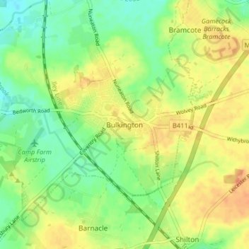
Nome: Mappa topografica Bulkington, altitudine, rilievo.
Altitudine media: 107 m
Altitudine minima: 90 m
Altitudine massima: 123 m
Altre mappe topografiche
Clicca su una mappa per visualizzarne la topografia, l'altitudine e il rilievo.
Nuneaton
United Kingdom > England > Warwickshire > Nuneaton and Bedworth
Nuneaton, Nuneaton and Bedworth, Warwickshire, England, CV11 5AB, United Kingdom
Altitudine media: 101 m
Nuneaton Common
United Kingdom > England > Warwickshire > Nuneaton and Bedworth
Nuneaton Common, Whittleford, Nuneaton and Bedworth, Warwickshire, England, United Kingdom
Altitudine media: 127 m
Ash Green
United Kingdom > England > Warwickshire > Nuneaton and Bedworth > Ash Green
Ash Green, Nuneaton and Bedworth, Warwickshire, England, CV7 9AQ, United Kingdom
Altitudine media: 111 m
Horeston Grange
United Kingdom > England > Warwickshire > Nuneaton and Bedworth
Horeston Grange, Nuneaton and Bedworth, Warwickshire, England, CV11 6YL, United Kingdom
Altitudine media: 90 m
Exhall
United Kingdom > England > Warwickshire > Nuneaton and Bedworth
Exhall, Nuneaton and Bedworth, Warwickshire, England, CV7 9DJ, United Kingdom
Altitudine media: 101 m
Bedworth
United Kingdom > England > Warwickshire > Nuneaton and Bedworth
Bedworth, Nuneaton and Bedworth, Warwickshire, England, CV12 9DQ, United Kingdom
Altitudine media: 105 m