
Mappa topografica Eminence
Mappa interattiva
Clicca sulla mappa per visualizzare l'altitudine.
A proposito di questa mappa
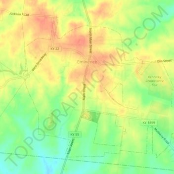
Nome: Mappa topografica Eminence, altitudine, rilievo.
Luogo: Eminence, Henry County, Kentucky, 40019, United States (38.35079 -85.19681 38.37916 -85.15221)
Altitudine media: 274 m
Altitudine minima: 249 m
Altitudine massima: 293 m
According to the United States Census Bureau, the city of Eminence has a total area of 2.9 square miles (7.4 km2), of which 0.04 square miles (0.1 km2), or 1.70%, is water. The city is located on high ground, with elevations up to 960 feet (290 m), where several watersheds converge. The source of the Little Kentucky River, a tributary of the Kentucky River, is just west of Eminence, while Town Creek to the north and Drennon Creek to the east also rise in Eminence and flow north to the Kentucky River. Fox Run rises in the southern part of Eminence and flows south via Bullskin Creek and Brashears Creek to the Salt River. The Kentucky and the Salt River are both tributaries of the Ohio River.
Altre mappe topografiche
Clicca su una mappa per visualizzarne la topografia, l'altitudine e il rilievo.
Pleasureville
United States > Kentucky > Henry County
Pleasureville, Henry County, Kentucky, United States
Altitudine media: 269 m