
Fai una donazione
Preparati per la tua prossima avventura:
In qualità di associato Amazon, questo sito riceve una commissione sugli acquisti idonei senza alcun costo aggiuntivo per te.
Mappa topografica Kotagiri
Clicca sulla mappa per visualizzare l'altitudine.
Fai una donazione
Preparati per la tua prossima avventura:
In qualità di associato Amazon, questo sito riceve una commissione sugli acquisti idonei senza alcun costo aggiuntivo per te.
Kotagiri
Kotagiri is a hill station and a municipality in the Nilgiris district of the Indian state, Tamil Nadu. The Nilgiri hills have been the traditional home of the "Kota" tribes. The name 'Kota-giri' itself means 'mountains of the kotas'. Kotagiri was known in the past as 'Kota-keri' or 'Kota-gherry', the 'street of Kotas'. The town has developed around numerous knolls and valleys. It is one of the largest hill stations in the Nilgiri Mountains. Located at an average elevation of 1,950 m (6,400 ft), Kotagiri is quietly tucked away in the Nilgiris and used to be one of the summer resorts of Madras Presidency. The town was discovered in the year 1819 by John Sullivan when he came to a village called Dhimbatty to the north of Kotagiri. Kotagiri enjoys the third coldest climate next to Ooty and Kodaikanal in South India.
Fai una donazione
Preparati per la tua prossima avventura:
In qualità di associato Amazon, questo sito riceve una commissione sugli acquisti idonei senza alcun costo aggiuntivo per te.
A proposito di questa mappa
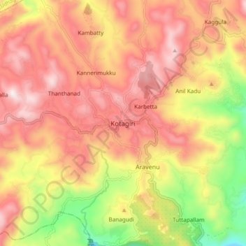
Nome: Mappa topografica Kotagiri, altitudine, rilievo.
Luogo: Kotagiri, Nilgiris, Tamil Nadu, 643217, India (11.38304 76.82582 11.46304 76.90582)
Altitudine media: 1.781 m
Altitudine minima: 1.290 m
Altitudine massima: 2.125 m
Fai una donazione
Preparati per la tua prossima avventura:
In qualità di associato Amazon, questo sito riceve una commissione sugli acquisti idonei senza alcun costo aggiuntivo per te.
Altre mappe topografiche
Clicca su una mappa per visualizzarne la topografia, l'altitudine e il rilievo.