
Fai una donazione
Preparati per la tua prossima avventura:
In qualità di associato Amazon, questo sito riceve una commissione sugli acquisti idonei senza alcun costo aggiuntivo per te.
Mappa topografica Mount Judi
Clicca sulla mappa per visualizzare l'altitudine.
Fai una donazione
Preparati per la tua prossima avventura:
In qualità di associato Amazon, questo sito riceve una commissione sugli acquisti idonei senza alcun costo aggiuntivo per te.
Mount Judi
The Arabic word al-Jūdiyy (ٱلْجُودِيّ), originates from the Syriac word Gudo (ܓܘܕܐ) meaning "Mounds" or "Elevations". The relation of some of the spellings is clear. The origin of Judi is less clear. It is usually interpreted as a corrupted version of the same name, via Al-Gurdi (Reynolds 2004). Since at least 697 BC, it was often held that after the ark came to rest on the mountain, Noah and the survivors of the flood (who were thought to have numbered 80) came down from it, and built this town to the south of the mountain, hence the name of Thamānīn (Arabic: ثَمَانِيْن, lit. 'Eighty'). The proposal that the two names are ultimately the same was first advanced by the English Orientalist George Sale. In his commentary about the Quran (11:4; the verse that mentions the landing of Noah's ark upon Al-Judiy), the English Orientalist George Sale said.
Fai una donazione
Preparati per la tua prossima avventura:
In qualità di associato Amazon, questo sito riceve una commissione sugli acquisti idonei senza alcun costo aggiuntivo per te.
A proposito di questa mappa
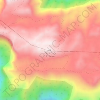
Nome: Mappa topografica Mount Judi, altitudine, rilievo.
Luogo: Mount Judi, Şırnak, Southeastern Anatolia Region, Turkey (37.37748 42.45426 37.37758 42.45436)
Altitudine media: 1.904 m
Altitudine minima: 1.464 m
Altitudine massima: 2.110 m
Fai una donazione
Preparati per la tua prossima avventura:
In qualità di associato Amazon, questo sito riceve una commissione sugli acquisti idonei senza alcun costo aggiuntivo per te.