
Fai una donazione
Preparati per la tua prossima avventura:
In qualità di associato Amazon, questo sito riceve una commissione sugli acquisti idonei senza alcun costo aggiuntivo per te.
Mappa topografica Kissena Park
Clicca sulla mappa per visualizzare l'altitudine.
Fai una donazione
Preparati per la tua prossima avventura:
In qualità di associato Amazon, questo sito riceve una commissione sugli acquisti idonei senza alcun costo aggiuntivo per te.
Kissena Park
Kissena Park's natural features were formed during the Wisconsin glaciation, about 20,000 years ago. The site of Flushing Meadows–Corona Park, slightly west of Kissena Park, was originally part of the ancestral path of the Hudson River, and the present-day Kissena Lake was located on the eastern shore of the river. The glacier covered much of Long Island, where Queens is located, and formed a terminal moraine through the center of the island. One of these recesses became Kissena Lake. When the glacier receded, it created several recesses in the land, some of which were filled with water. The topography of Flushing and Northeast Queens was formed during this time, including the creation of Kissena Lake. Glaciation also created a natural source of well water for the area.
Fai una donazione
Preparati per la tua prossima avventura:
In qualità di associato Amazon, questo sito riceve una commissione sugli acquisti idonei senza alcun costo aggiuntivo per te.
A proposito di questa mappa
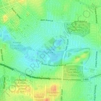
Nome: Mappa topografica Kissena Park, altitudine, rilievo.
Luogo: Kissena Park, Queens County, New York, United States (40.74207 -73.81415 40.75003 -73.80290)
Altitudine media: 16 m
Altitudine minima: 1 m
Altitudine massima: 41 m
Fai una donazione
Preparati per la tua prossima avventura:
In qualità di associato Amazon, questo sito riceve una commissione sugli acquisti idonei senza alcun costo aggiuntivo per te.
Altre mappe topografiche
Clicca su una mappa per visualizzarne la topografia, l'altitudine e il rilievo.
Washington Heights
United States > New York > New York
Because of their abrupt, hilly topography, pedestrian navigation in Upper Manhattan is facilitated by many step streets. The longest of these in Washington Heights, at approximately 130 stairs and with an elevation gain of approximately 65 feet, connects Fort Washington Avenue and Overlook Terrace at 187th…
Altitudine media: 25 m
Fai una donazione
Preparati per la tua prossima avventura:
In qualità di associato Amazon, questo sito riceve una commissione sugli acquisti idonei senza alcun costo aggiuntivo per te.
Manhattan Island
United States > New York > New York
Marble Hill is one example of how Manhattan's land has been considerably altered by human intervention. The borough has seen substantial land reclamation along its waterfronts since Dutch colonial times, and much of the natural variation in its topography has been evened out.
Altitudine media: 17 m
Fai una donazione
Preparati per la tua prossima avventura:
In qualità di associato Amazon, questo sito riceve una commissione sugli acquisti idonei senza alcun costo aggiuntivo per te.