
Mappa topografica Scholar Green
Clicca sulla mappa per visualizzare l'altitudine.
A proposito di questa mappa
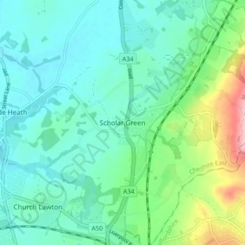
Nome: Mappa topografica Scholar Green, altitudine, rilievo.
Luogo: Scholar Green, Cheshire East, England, ST7 3HH, United Kingdom (53.09157 -2.27417 53.13157 -2.23417)
Altitudine media: 124 m
Altitudine minima: 85 m
Altitudine massima: 254 m
Altre mappe topografiche
Clicca su una mappa per visualizzarne la topografia, l'altitudine e il rilievo.
Alderley Edge
United Kingdom > England > Cheshire East
Alderley Edge is 6 miles (10 km) northwest of Macclesfield and 12 miles (19 km) south of Manchester, at the base of a steep and thickly wooded sandstone escarpment, Alderley Edge, which is the area's chief topographical feature and overlooks the Cheshire Plain.
Altitudine media: 91 m
Peckforton Moss
United Kingdom > England > Cheshire East > Bulkeley > Peckforton
Altitudine media: 100 m
Mottram St. Andrew
United Kingdom > England > Cheshire East > Mottram St Andrew
Altitudine media: 105 m