
Mappa topografica Hyderabad
Clicca sulla mappa per visualizzare l'altitudine.
Hyderabad
Hyderabad (/ˈhaɪdərəbæd/ HY-dər-ə-bad; Telugu: [ˈɦaɪ̯daraːbaːd], Urdu: [ˈɦɛːdəɾaːbaːd]) is the capital and largest city of the Indian state of Telangana. It occupies 650 km2 (250 sq mi) on the Deccan Plateau along the banks of the Musi River, in the northern part of Southern India. With an average altitude of 542 m (1,778 ft), much of Hyderabad is situated on hilly terrain around artificial lakes, including the Hussain Sagar lake, predating the city's founding, in the north of the city centre. According to the 2011 Census of India, Hyderabad is the fourth-most populous city in India with a population of 6.9 million residents within the city limits, and has a population of 9.7 million residents in the metropolitan region, making it the sixth-most populous metropolitan area in India. With an output of US$74 billion, Hyderabad has the fifth-largest urban economy in India.
A proposito di questa mappa
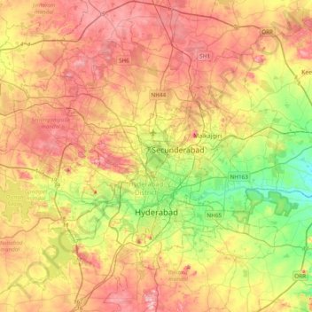
Nome: Mappa topografica Hyderabad, altitudine, rilievo.
Luogo: Hyderabad, Bahadurpura mandal, Hyderabad, Telangana, India (17.29164 78.23871 17.56083 78.62239)
Altitudine media: 549 m
Altitudine minima: 447 m
Altitudine massima: 649 m
Altre mappe topografiche
Clicca su una mappa per visualizzarne la topografia, l'altitudine e il rilievo.