
Fai una donazione
Preparati per la tua prossima avventura:
In qualità di associato Amazon, questo sito riceve una commissione sugli acquisti idonei senza alcun costo aggiuntivo per te.
Mappa topografica Rio Vista
Clicca sulla mappa per visualizzare l'altitudine.
Fai una donazione
Preparati per la tua prossima avventura:
In qualità di associato Amazon, questo sito riceve una commissione sugli acquisti idonei senza alcun costo aggiuntivo per te.
A proposito di questa mappa
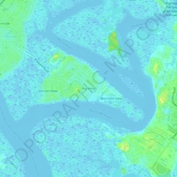
Nome: Mappa topografica Rio Vista, altitudine, rilievo.
Luogo: Rio Vista, Chatham County, Georgia, 31411, United States (31.90938 -81.10789 31.94938 -81.06789)
Altitudine media: 3 m
Altitudine minima: -4 m
Altitudine massima: 20 m
Fai una donazione
Preparati per la tua prossima avventura:
In qualità di associato Amazon, questo sito riceve una commissione sugli acquisti idonei senza alcun costo aggiuntivo per te.
Altre mappe topografiche
Clicca su una mappa per visualizzarne la topografia, l'altitudine e il rilievo.
Savannah
United States > Georgia > Chatham County
Savannah is characterized by a unique and varied topography shaped by its coastal location and historical development. The city is situated on a series of low bluffs along the Savannah River, which flows into the Atlantic Ocean approximately 18 miles (29 km) away. The terrain features a mix of flat coastal…
Altitudine media: 4 m
Fai una donazione
Preparati per la tua prossima avventura:
In qualità di associato Amazon, questo sito riceve una commissione sugli acquisti idonei senza alcun costo aggiuntivo per te.
Fai una donazione
Preparati per la tua prossima avventura:
In qualità di associato Amazon, questo sito riceve una commissione sugli acquisti idonei senza alcun costo aggiuntivo per te.
Savannah
United States > Georgia > Chatham County
Savannah is prone to flooding, due to abundant rainfall, an elevation at just above sea level, and the shape of the coastline, which poses a greater surge risk during hurricanes. The city currently uses five canals. In addition, several pumping stations have been built to help reduce the effects of flash…
Altitudine media: 4 m
Savannah
United States > Georgia > Chatham County
Savannah is prone to flooding due to abundant rainfall, an elevation just above sea level, and the shape of the coastline, which poses a greater surge risk during hurricanes. The city currently uses five canals. In addition, several pumping stations have been built to help reduce the effects of flash flooding.
Altitudine media: 4 m
Fai una donazione
Preparati per la tua prossima avventura:
In qualità di associato Amazon, questo sito riceve una commissione sugli acquisti idonei senza alcun costo aggiuntivo per te.
Savannah
United States > Georgia > Chatham County
Savannah is prone to flooding due to abundant rainfall, an elevation just above sea level, and the shape of the coastline, which poses a greater surge risk during hurricanes. The city currently uses five canals. In addition, several pumping stations have been built to help reduce the effects of flash flooding.
Altitudine media: 4 m
Fai una donazione
Preparati per la tua prossima avventura:
In qualità di associato Amazon, questo sito riceve una commissione sugli acquisti idonei senza alcun costo aggiuntivo per te.
Savannah
United States > Georgia > Chatham County
Savannah is prone to flooding, due to abundant rainfall, an elevation at just above sea level, and the shape of the coastline, which poses a greater surge risk during hurricanes. The city currently uses five canals. In addition, several pumping stations have been built to help reduce the effects of flash…
Altitudine media: 4 m
Fai una donazione
Preparati per la tua prossima avventura:
In qualità di associato Amazon, questo sito riceve una commissione sugli acquisti idonei senza alcun costo aggiuntivo per te.