
Fai una donazione
Preparati per la tua prossima avventura:
In qualità di associato Amazon, questo sito riceve una commissione sugli acquisti idonei senza alcun costo aggiuntivo per te.
Mappa topografica Gunnison
Clicca sulla mappa per visualizzare l'altitudine.
Fai una donazione
Preparati per la tua prossima avventura:
In qualità di associato Amazon, questo sito riceve una commissione sugli acquisti idonei senza alcun costo aggiuntivo per te.
Gunnison
Also in 1880, the cattle industry in Gunnison was established. Realizing the poor conditions for farming (with only about eleven inches of rainfall annually and the short growing season due to the high elevation and alpine environment) the local farmers turned to ranching and began breeding cattle. To do this effectively, they had to clear and level fields for grazing purposes. Irrigation ditches also had to be cut into the ground to properly irrigate the fields in order to grow hay for the horses and cattle. Many of these practices are still in use, which can be seen while driving through and around the town to the various ranches that are still in operation.
Fai una donazione
Preparati per la tua prossima avventura:
In qualità di associato Amazon, questo sito riceve una commissione sugli acquisti idonei senza alcun costo aggiuntivo per te.
A proposito di questa mappa
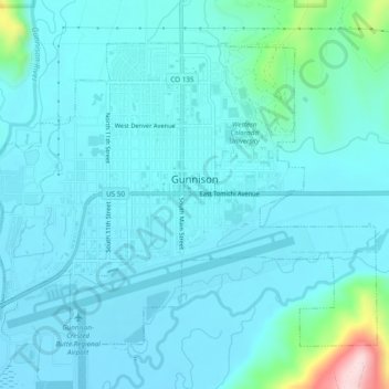
Nome: Mappa topografica Gunnison, altitudine, rilievo.
Luogo: Gunnison, Gunnison County, Colorado, United States (38.52956 -106.95098 38.55905 -106.90267)
Altitudine media: 2.369 m
Altitudine minima: 2.332 m
Altitudine massima: 2.633 m
Fai una donazione
Preparati per la tua prossima avventura:
In qualità di associato Amazon, questo sito riceve una commissione sugli acquisti idonei senza alcun costo aggiuntivo per te.