
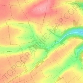
Mappa topografica Darstadt
Clicca sulla mappa per visualizzare l'altitudine.
A proposito di questa mappa
Nome: Mappa topografica Darstadt, altitudine, rilievo.
Luogo: Darstadt, Ochsenfurt, Landkreis Würzburg, Bayern, Deutschland (49.67197 9.99069 49.67725 10.00537)
Altitudine media: 278 m
Altitudine minima: 212 m
Altitudine massima: 315 m
Altre mappe topografiche
Clicca su una mappa per visualizzarne la topografia, l'altitudine e il rilievo.
Goßmannsdorf
Deutschland > Bayern > Landkreis Würzburg > Ochsenfurt
Vom 14. bis ins 19. Jahrhundert hatte der Ort eine geschlossene Dorfbefestigung, die aus einer Ringmauer mit drei großen und sieben kleinen Türmen bestand. Sie ist nur noch teilweise in ihrer alten Höhe erhalten.
Altitudine media: 246 m