Geolocalizza

Mappa topografica Civitella Casanova

Mappa interattiva

Clicca sulla mappa per visualizzare l'altitudine.

A proposito di questa mappa

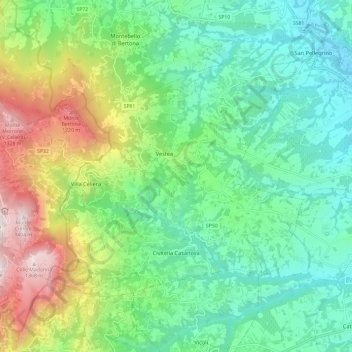
Nome: Mappa topografica Civitella Casanova, altitudine, rilievo.

Luogo: Civitella Casanova, Pescara, Abruzzo, Italy (42.35367 13.81373 42.41376 13.93272)

Altitudine media: 540 m

Altitudine minima: 166 m

Altitudine massima: 1.407 m

The current village, growing, grew in the foothills of the majestic Gran Sasso chain at the foot of Mount Cimoni—elevation 1,404 metres (4,606 ft), and Mt Colle Madonna, elevation 1,350 metres (4,430 ft)—from a village, relatively old and homely in dimensions, called Terravecchia. Built of stone and brick, this small village is situated on a rocky outcrop and is the most remote and evocative of the historic center in Roman times was called Cutina or Cingilia. On it stood the ponderous Castrum Rossi di Civitella, which was destroyed by a disastrous earthquake in 1456, and the Church of San Marco which today remains only a stone, on which there was built a new house, but left intentionally exposed by the owners. Subsequently, many buildings were swallowed by a landslide which brought with it a large part of the area, reducing the current strip of land we see today. Conseguenzialmente these events there was a need for the development of a new country: its subsequent expansion, in fact, led him to develop the hill to the west, up the slopes of the mountain. Its elongated shape today is crossed by a long straight axis, which some believe is one of the longer courses available throughout the province, bordered by rows of houses almost uninterrupted. Terravecchia is now very attractive, because of its walls stone and brick, the winding streets and steep stairways, and its architecture is still of considerable interest. The two nuclei are gathered today, and there are buildings of superior construction quality. The elevation of the town is known to be 400 metres (1,300 ft) above sea level, the point at which it is built the municipal building: few people know, however, that the highest point of the municipality measuring 1,581 metres (5,187 ft), height of the mountain Top of Cioccola observable by the fraction Baffo and Centelle, part of the town of Civitella. It sopraeleva behind the mountains above Cimoni and Colle Madonna forming the plain with lace, or a barrier of rock composed of limestone pinnacles, which in fact is the door of the flat Voltigno. Civitella in higher altitudes has a large area of this plateau, which includes the three mountains of the town, because in these places has the typical characteristic landscape mountain, where there are large beech and oak and fir trees, we can find the area of wildlife chamois 'Abruzzo, where there are also buzzards, peregrine falcons, deer, the Apennine wolf, wild cat, and once the bear. Excellent destination for mountain lovers and for those who love to be surrounded by greenery, close to the country from which you can see, looking towards the mountains, this pristine nature. The plateau of Voltigno is about 1,300 metres (4,300 ft) above sea level and is often visited by tourists and people who love the mountains, but there is also practiced sports, including cycling and cross-country skiing in winter. Just here, on the mountain Colle Madonna, originates the source of Rivo Clear that, by the eponymous waterfall frozen in winter (great for climbing mountaineering, gives rise to stream Schiavone, fed by the waters of the Festina river, then the river confluence Nora. There is also a small karst lake, fed mainly by snowfall winter, Lake Background, the only one that dries up in summer in spite of the other small ponds that have the same origin. According to popular belief, the lake has no bottom and flows directly into the Adriatic Sea. Civitella Casanova also has a large area of natural interest outside the city center, in the district Furnace, you can visit the Zoo Park, the Cliff, while to the north of the Hill truncheons, in Festina location at 790 metres (2,590 ft) above sea level there is a spring of sulphurous water [15], usually not easily recepibile and conducive to many cures for acne, arthritis, asthma-like bronchitis, catarrhal bronchitis, eczema seborrico, lymphatism eretistico, acute articular rheumatism, rinofaringo - chronic laryngitis, deafness . [16] In addition, however, also become a tourist spot of the high mountains of the town and turned into a pretty fountain, there are mountains in at least three other main sources for drinking water:

Wikipedia (CC-BY-SA 3.0)

Altre mappe topografiche

Clicca su una mappa per visualizzarne la topografia, l'altitudine e il rilievo.

Pagliari

Italy > Abruzzo > Pescara > Roccamorice

Pagliari, Roccamorice, Pescara, Abruzzo, Italy

Altitudine media: 623 m

Fonte Tettone

Italy > Abruzzo > Pescara > Roccamorice

Fonte Tettone, Roccamorice, Pescara, Abruzzo, Italy

Altitudine media: 1.507 m

Abbateggio

Italy > Abruzzo > Pescara

Abbateggio, Pescara, Abruzzo, Italy

Altitudine media: 573 m

Picciano

Italy > Abruzzo > Pescara

Picciano, Pescara, Abruzzo, Italy

Altitudine media: 139 m

Bolognano

Italy > Abruzzo > Pescara

Bolognano, Pescara, Abruzzo, Italy

Altitudine media: 407 m

Sant'Eufemia a Maiella

Italy > Abruzzo > Pescara

Sant'Eufemia a Maiella, Pescara, Abruzzo, Italy

Altitudine media: 1.377 m

Cona

Italy > Abruzzo > Pescara > Brittoli

Cona, Brittoli, Pescara, Abruzzo, Italy

Altitudine media: 818 m

Brittoli

Italy > Abruzzo > Pescara

Brittoli, Pescara, Abruzzo, Italy

Altitudine media: 674 m

Cugnoli

Italy > Abruzzo > Pescara > Turrivalignani

Cugnoli, Turrivalignani, Pescara, Abruzzo, 65024, Italy

Altitudine media: 203 m

Carpineto della Nora

Italy > Abruzzo > Pescara

Carpineto della Nora, Pescara, Abruzzo, Italy

Altitudine media: 756 m

Villa Celiera

Italy > Abruzzo > Pescara

Villa Celiera, Pescara, Abruzzo, Italy

Altitudine media: 812 m

Bussi sul Tirino

Italy > Abruzzo > Pescara

Bussi sul Tirino, Pescara, Abruzzo, 65022, Italy

Altitudine media: 607 m

11

Italy > Abruzzo > Pescara > Brittoli > Boragne

11, Boragne, Brittoli, Pescara, Abruzzo, 65010, Italy

Altitudine media: 603 m

Castiglione a Casauria

Italy > Abruzzo > Pescara

Castiglione a Casauria, Pescara, Abruzzo, Italy

Altitudine media: 432 m

La Maielletta

Italy > Abruzzo > Pescara > Roccamorice

La Maielletta, Roccamorice, Pescara, Abruzzo, Italy

Altitudine media: 1.694 m

Salle

Italy > Abruzzo > Pescara

Salle, Pescara, Abruzzo, Italy

Altitudine media: 881 m

Alanno

Italy > Abruzzo > Pescara

Alanno, Pescara, Abruzzo, Italy

Altitudine media: 213 m

Vestea

Italy > Abruzzo > Pescara

Vestea, Civitella Casanova, Pescara, Abruzzo, Italy

Altitudine media: 540 m

Caramanico Terme

Italy > Abruzzo > Pescara

Caramanico Terme, Pescara, Abruzzo, 65023, Italy

Altitudine media: 954 m

Pescara

Italy > Abruzzo > Pescara > Pescara

Pescara, Abruzzo, Italy

Altitudine media: 34 m

Scafa

Italy > Abruzzo > Pescara > Scafa

Scafa, Pescara, Abruzzo, Italy

Altitudine media: 253 m

San Valentino in Abruzzo Citeriore

Italy > Abruzzo > Pescara > San Valentino in Abruzzo Citeriore

San Valentino in Abruzzo Citeriore, Pescara, Abruzzo, Italy

Altitudine media: 330 m

Città Sant'Angelo

Italy > Abruzzo > Pescara > Città Sant'Angelo > Città Sant'Angelo

Città Sant'Angelo, Pescara, Abruzzo, 65013, Italy

Altitudine media: 123 m

Pietranico

Italy > Abruzzo > Pescara > Pietranico

Pietranico, Pescara, Abruzzo, Italy

Altitudine media: 396 m

Civitaquana

Italy > Abruzzo > Pescara

Civitaquana, Pescara, Abruzzo, Italy

Altitudine media: 466 m

Roccacaramanico

Italy > Abruzzo > Pescara > Sant'Eufemia a Maiella

Roccacaramanico, Sant'Eufemia a Maiella, Pescara, Abruzzo, Italy

Altitudine media: 1.172 m

Corvara

Italy > Abruzzo > Pescara

Corvara, Pescara, Abruzzo, Italy

Altitudine media: 644 m

Lettomanoppello

Italy > Abruzzo > Pescara

Lettomanoppello, Pescara, Abruzzo, Italy

Altitudine media: 543 m

Loreto Aprutino

Italy > Abruzzo > Pescara

Loreto Aprutino, Pescara, Abruzzo, 65014, Italy

Altitudine media: 226 m