
Mappa topografica Arciprestazgo de Alcalá Sur
Mappa interattiva
Clicca sulla mappa per visualizzare l'altitudine.
A proposito di questa mappa
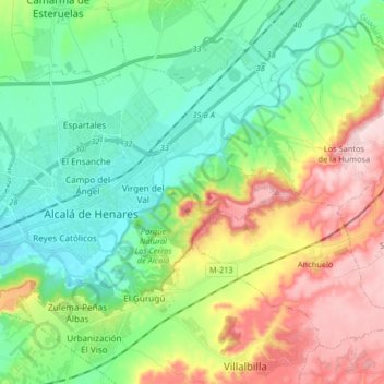
Nome: Mappa topografica Arciprestazgo de Alcalá Sur, altitudine, rilievo.
Altitudine media: 685 m
Altitudine minima: 576 m
Altitudine massima: 899 m
Standing at an average altitude of 654 m, and occupying some 88 km2; the city was for a long time contained in between the Henares to the South and the Madrid-Barcelona railway to the North. However, the increasing population brought on the sprawl of the urbanised area to the area located in between the railway and the A-2 motorway and beyond.