
Mappa topografica Vinhais
Mappa interattiva
Clicca sulla mappa per visualizzare l'altitudine.
A proposito di questa mappa
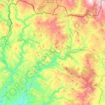
Nome: Mappa topografica Vinhais, altitudine, rilievo.
Luogo: Vinhais, Bragança, Portugal (41.67113 -7.21360 41.99076 -6.86096)
Altitudine media: 779 m
Altitudine minima: 258 m
Altitudine massima: 1.527 m
It is perched on the slopes of the Coroa mountains at an altitude of approximately 600 meters, protected from the cold winds of the north by the Ciradelha mountain, where in remote times there was a Luso-Roman castro. On the south side is the Tuela River valley. There are three other rivers in the concelho: the Rabaçal, the Mente, and the Baceiro. They are relatively unpolluted and provide fish for locals and tourists. The Baceiro has a trout hatchery which is deactivated but will be reopened soon.
Altre mappe topografiche
Clicca su una mappa per visualizzarne la topografia, l'altitudine e il rilievo.
Penhas Juntas
Penhas Juntas, Vinhais, Bragança, Portugal
Altitudine media: 715 m
Montesinho Nature Park
Portugal > Bragança > Bragança > Espinhosela
Montesinho Nature Park, Espinhosela, Bragança, 5300-245, Portugal
Altitudine media: 881 m
Carrazeda de Ansiães
Carrazeda de Ansiães, Bragança, Portugal
Altitudine media: 538 m
Macedo de Cavaleiros
Portugal > Bragança > Macedo de Cavaleiros
Macedo de Cavaleiros, Bragança, Portugal
Altitudine media: 594 m
Mua
Portugal > Bragança > Torre de Moncorvo
Mua, Torre de Moncorvo, Bragança, Portugal
Altitudine media: 695 m