
Mappa topografica Kālāhandi
Clicca sulla mappa per visualizzare l'altitudine.
A proposito di questa mappa
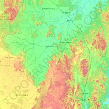
Nome: Mappa topografica Kālāhandi, altitudine, rilievo.
Luogo: Kālāhandi, Kalahandi District, Odisha, India (19.05000 82.30000 20.45000 83.70000)
Altitudine media: 452 m
Altitudine minima: 122 m
Altitudine massima: 1.498 m
Altre mappe topografiche
Clicca su una mappa per visualizzarne la topografia, l'altitudine e il rilievo.
Jagatsinghapur
Jagatsinghpur is situated on an elevation of 15 meters (49 feet). It is the smallest district in the state and covers a landmass of 1759 km2. The place lies between 8603' to 86045' East Longitude and between 19058' to 20023' North latitude. It is predominantly recognized due to its triangular geographical…
Altitudine media: 6 m
Nabarangapur
Nabarangpur district, also known as Nabarangapur district and Nawarangpur district, is a district of Odisha, India. The city of Nabarangpur is the district capital. Most of its population is tribal and the land is heavily forested. It borders Kalahandi and Koraput districts. Nabarangpur district is situated at…
Altitudine media: 530 m
Angul
Angul is located in the centre of the state of Odisha and lies between the latitudes of 20°31′N and 21°40′N and longitudes of 84°15′E and 85°23′E. The altitude is between 564 and 1,187 metres (1,850 and 3,894 ft). The district has an area of 6,232 km2 (2,406 sq mi). It is bounded by Dhenkanal and…
Altitudine media: 234 m