
Fai una donazione
Preparati per la tua prossima avventura:
In qualità di associato Amazon, questo sito riceve una commissione sugli acquisti idonei senza alcun costo aggiuntivo per te.
Mappa topografica Brund Fell (summit)
Clicca sulla mappa per visualizzare l'altitudine.
Fai una donazione
Preparati per la tua prossima avventura:
In qualità di associato Amazon, questo sito riceve una commissione sugli acquisti idonei senza alcun costo aggiuntivo per te.
Brund Fell (summit)
The fell has a summit plateau which consist of many heather-covered hummocks, drystone walls and clumps of trees. Well-known Lake District writer Alfred Wainwright credits Grange Fell as a single fell with three main summits, namely Brund Fell, King's How and Ether Knott. The lesser known Ether Knott is now identified as the highest point at a height of 419 metres (1,375 feet) and is less frequently visited by walkers. Brund Fell is at 415 metres (1,362 feet) while King's How is the best viewpoint and has an altitude of 392 metres (1,286 feet). On the other hand, another Lakes walking expert Bill Birkett lists Brund Fell and King's How as separate fells in his “Complete Lakeland Fells” volume, while Mark Richards includes all three.
Fai una donazione
Preparati per la tua prossima avventura:
In qualità di associato Amazon, questo sito riceve una commissione sugli acquisti idonei senza alcun costo aggiuntivo per te.
A proposito di questa mappa
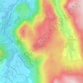
Nome: Mappa topografica Brund Fell (summit), altitudine, rilievo.
Altitudine media: 252 m
Altitudine minima: 78 m
Altitudine massima: 455 m
Fai una donazione
Preparati per la tua prossima avventura:
In qualità di associato Amazon, questo sito riceve una commissione sugli acquisti idonei senza alcun costo aggiuntivo per te.
Altre mappe topografiche
Clicca su una mappa per visualizzarne la topografia, l'altitudine e il rilievo.