Geolocalizza

Mappa topografica Wrightwood

Clicca sulla mappa per visualizzare l'altitudine.

Wrightwood

Wrightwood is a census-designated place in San Bernardino County, California. It sits at an elevation of 6,000 feet (1,800 m). The population was 4,525 at the 2010 census, up from the population of 3,837 at the 2000 census. Wrightwood is located 77 miles (124 km) northeast of Los Angeles. Wrightwood is on the Pacific Crest Trail.

Wikipedia (CC-BY-SA 3.0)

A proposito di questa mappa

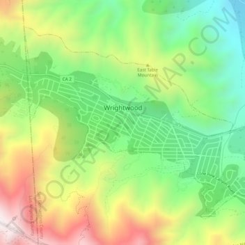
Nome: Mappa topografica Wrightwood, altitudine, rilievo.

Luogo: Wrightwood, San Bernardino County, California, 92397, United States (34.33955 -117.65333 34.37329 -117.60239)

Altitudine media: 1.987 m

Altitudine minima: 1.555 m

Altitudine massima: 2.540 m

Altre mappe topografiche

Clicca su una mappa per visualizzarne la topografia, l'altitudine e il rilievo.

Fort Irwin

United States > California > San Bernardino County

Fort Irwin National Training Center (Fort Irwin NTC) is a major training area for the United States military in the Mojave Desert in northern San Bernardino County, California. Fort Irwin is at an average elevation of 2,454 feet (748 m). It is located 37 miles (60 km) northeast of Barstow, in the Calico…

Altitudine media: 774 m

Running Springs

United States > California > San Bernardino County > Running Springs

Running Springs is a mountain community in the San Bernardino Mountains. It is an inholding in the San Bernardino National Forest. Situated at the junction of State Route 18 and State Route 330, it is a major gateway to the mountain communities of Lake Arrowhead, Arrowbear, Green Valley Lake, and Big Bear and…

Altitudine media: 1.656 m

Cajon Pass

United States > California > San Bernardino County

Cajon Pass (/kəˈhoʊn/; Spanish: Puerto del Cajón or Paso del Cajón) is a mountain pass between the San Bernardino Mountains to the east and the San Gabriel Mountains to the west in Southern California. Created by the movements of the San Andreas Fault, it has an elevation of 3,777 ft (1,151 m). Located in…

Altitudine media: 1.169 m

San Gorgonio Mountain

United States > California > San Bernardino County

Since it is the highest point in a region which is separated from higher peaks (e.g. in the Sierra Nevada) by relatively low terrain, San Gorgonio Mountain is one of the most topographically prominent peaks in the United States. It is ranked 7th among peaks in the 48 contiguous states and 18th overall.

Altitudine media: 3.154 m

Arrowbear Lake

United States > California > San Bernardino County > Running Springs

Arrowbear Lake is an unincorporated community in San Bernardino County, California, United States. Its altitude is 6,086 feet (1,855 m) in the San Bernardino Mountains. It is located east of Running Springs along Highway 18 in the San Bernardino National Forest, a mountain community with a population of 736 in…

Altitudine media: 1.928 m

Running Springs

United States > California > San Bernardino County

Running Springs is a mountain community in the San Bernardino Mountains. It is an inholding in the San Bernardino National Forest. Situated at the junction of State Route 18 and State Route 330, it is a major gateway to the mountain communities of Lake Arrowhead, Arrowbear, Green Valley Lake, and Big Bear and…

Altitudine media: 1.673 m

Cucamonga Peak

United States > California > San Bernardino County

Cucamonga Peak is one of the highest peaks of the San Gabriel Mountains in San Bernardino County, California, with a summit elevation of 8,862 feet (2,701 m). It is within the Cucamonga Wilderness of the San Bernardino National Forest.

Altitudine media: 2.240 m

Running Springs

United States > California > San Bernardino County

Running Springs is a mountain community in the San Bernardino Mountains. It is an inholding in the San Bernardino National Forest. Situated at the junction of State Route 18 and State Route 330, it is a major gateway to the mountain communities of Lake Arrowhead, Arrowbear, Green Valley Lake, and Big Bear and…

Altitudine media: 1.673 m

Running Springs

United States > California > San Bernardino County > Running Springs

Running Springs is a mountain community in the San Bernardino Mountains. It is an inholding in the San Bernardino National Forest. Situated at the junction of State Route 18 and State Route 330, it is a major gateway to the mountain communities of Lake Arrowhead, Arrowbear, Green Valley Lake, and Big Bear and…

Altitudine media: 1.656 m

Preparati per la tua prossima avventura:

🦯Bastoncini da Trekking - Bastoni leggeri in alluminio o carbonio per ridurre il carico sulle articolazioni
🔥Acciarini e Fuoco - Strumenti per accendere il fuoco in qualsiasi condizione meteo
🧥Piumini Compattabili - Giacche calde che occupano pochissimo spazio nello zaino
🧥Giacche impermeabili trekking - Protezione contro pioggia e vento
🥾Scarponi da Trekking - Calzature robuste e impermeabili per ogni tipo di sentiero e terreno

In qualità di associato Amazon, questo sito riceve una commissione sugli acquisti idonei senza alcun costo aggiuntivo per te.