
Mappa topografica High Roding
Clicca sulla mappa per visualizzare l'altitudine.
A proposito di questa mappa
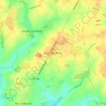
Nome: Mappa topografica High Roding, altitudine, rilievo.
Luogo: High Roding, Uttlesford, Essex, England, CM6 1YH, United Kingdom (51.81016 0.30609 51.85016 0.34609)
Altitudine media: 79 m
Altitudine minima: 61 m
Altitudine massima: 93 m
Altre mappe topografiche
Clicca su una mappa per visualizzarne la topografia, l'altitudine e il rilievo.
Coles Green
United Kingdom > England > Essex > Uttlesford > Berden > Little London
Altitudine media: 100 m
Stansted Mountfitchet
United Kingdom > England > Essex > Uttlesford > Stansted Mountfitchet
Altitudine media: 89 m
Little Easton
United Kingdom > England > Essex > Uttlesford > Little Easton
Living in the parish were Lord and Lady Brooke, the later Earl and Countess of Warwick, at Easton Lodge, who were also resident at Berwick House in the Stable Yard of St James's Palace, London, and in 1902, after elevation to title, Warwick Castle. Parish occupations in 1882 included three farmers, one of whom…
Altitudine media: 88 m
Great Hallingbury
United Kingdom > England > Essex > Uttlesford > Great Hallingbury
Altitudine media: 81 m