
Mappa topografica Lake Massapoag
Mappa interattiva
Clicca sulla mappa per visualizzare l'altitudine.
A proposito di questa mappa
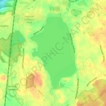
Nome: Mappa topografica Lake Massapoag, altitudine, rilievo.
Altitudine media: 84 m
Altitudine minima: 61 m
Altitudine massima: 98 m
Because of the lake and the fact that Sharon is at a slightly higher elevation than the surrounding towns, and because it is located on the main rail line going south from Boston, the shores of the lake developed into a minor summer resort with several large hotels, summer camps and cottage colonies. Temple Adath Sharon was built as a summer synagogue, and the houses around it, now occupied year-round, were once summer cottages.