
Fai una donazione
Preparati per la tua prossima avventura:
In qualità di associato Amazon, questo sito riceve una commissione sugli acquisti idonei senza alcun costo aggiuntivo per te.
Mappa topografica Muscatine
Clicca sulla mappa per visualizzare l'altitudine.
Fai una donazione
Preparati per la tua prossima avventura:
In qualità di associato Amazon, questo sito riceve una commissione sugli acquisti idonei senza alcun costo aggiuntivo per te.
Muscatine
Several large working-class neighborhoods and industrial sectors have been built on what is called "Muscatine Island". This flat, sandy expanse was largely underwater before a portion of the Mississippi River rerouted to follow the course of the present-day Muscatine Slough. It is unclear when the river changed course. The hills, river, and island are all integral to the diversity of Muscatine's economy and housing sector. As the city's urbanized area develops, the areas of highest elevation in the "High Prairie" crescent (between the Cedar and Mississippi Rivers) are increasingly taken from agricultural use and developed as suburban housing.
Fai una donazione
Preparati per la tua prossima avventura:
In qualità di associato Amazon, questo sito riceve una commissione sugli acquisti idonei senza alcun costo aggiuntivo per te.
A proposito di questa mappa
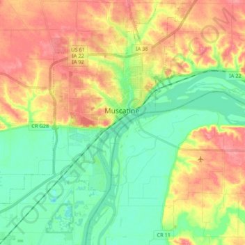
Nome: Mappa topografica Muscatine, altitudine, rilievo.
Luogo: Muscatine, Muscatine County, Iowa, 52761, United States (41.35852 -91.16135 41.47879 -90.99711)
Altitudine media: 189 m
Altitudine minima: 155 m
Altitudine massima: 233 m
Fai una donazione
Preparati per la tua prossima avventura:
In qualità di associato Amazon, questo sito riceve una commissione sugli acquisti idonei senza alcun costo aggiuntivo per te.
Altre mappe topografiche
Clicca su una mappa per visualizzarne la topografia, l'altitudine e il rilievo.