
Mappa topografica Brookings County
Mappa interattiva
Clicca sulla mappa per visualizzare l'altitudine.
A proposito di questa mappa
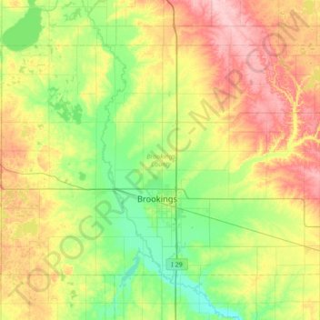
Nome: Mappa topografica Brookings County, altitudine, rilievo.
Luogo: Brookings County, South Dakota, United States (44.19593 -97.12974 44.54378 -96.45182)
Altitudine media: 525 m
Altitudine minima: 472 m
Altitudine massima: 617 m
Brookings County is on the east side of South Dakota. Its east boundary line abuts the west boundary line of the state of Minnesota. The Big Sioux River flows south-southeastward through the east central part of the county; its point of entry into Moody County marks Brookings County's lowest elevation: 1,568' (478m) ASL.
Altre mappe topografiche
Clicca su una mappa per visualizzarne la topografia, l'altitudine e il rilievo.
Brookings
United States > South Dakota > Brookings County
Brookings, Brookings County, South Dakota, United States
Altitudine media: 495 m