
Fai una donazione
Preparati per la tua prossima avventura:
In qualità di associato Amazon, questo sito riceve una commissione sugli acquisti idonei senza alcun costo aggiuntivo per te.
Mappa topografica Cloudcroft
Clicca sulla mappa per visualizzare l'altitudine.
Fai una donazione
Preparati per la tua prossima avventura:
In qualità di associato Amazon, questo sito riceve una commissione sugli acquisti idonei senza alcun costo aggiuntivo per te.
Cloudcroft
Its high elevation of 8,676 feet (2,644 m) allows for a mild summer, and the forested mountains make it a tourist attraction for the surrounding deserts. Tourism is the primary economy of the village.
Fai una donazione
Preparati per la tua prossima avventura:
In qualità di associato Amazon, questo sito riceve una commissione sugli acquisti idonei senza alcun costo aggiuntivo per te.
A proposito di questa mappa
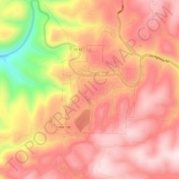
Nome: Mappa topografica Cloudcroft, altitudine, rilievo.
Luogo: Cloudcroft, Otero County, New Mexico, United States (32.94456 -105.75004 32.96421 -105.70277)
Altitudine media: 2.643 m
Altitudine minima: 2.352 m
Altitudine massima: 2.776 m
Fai una donazione
Preparati per la tua prossima avventura:
In qualità di associato Amazon, questo sito riceve una commissione sugli acquisti idonei senza alcun costo aggiuntivo per te.
Altre mappe topografiche
Clicca su una mappa per visualizzarne la topografia, l'altitudine e il rilievo.
High Rolls
United States > New Mexico > Otero County
The first official use of the High Rolls name was in 1901, when the post office was moved from Fresnal (Wooten) to High Rolls. The name, which was sometimes spelled as one word, Highrolls, supposedly came from the shape and elevation of the area as compared to the sharper peaks higher up.
Altitudine media: 2.036 m
Sunspot
United States > New Mexico > Otero County
Sunspot is an unincorporated community in the Sacramento Mountains in the Lincoln National Forest in Otero County, New Mexico, United States, about 18 miles (29 km) south of Cloudcroft. Its elevation is 9,186 feet (2,800 m). The Sunspot Solar Observatory and Apache Point Observatory are located in Sunspot in…
Altitudine media: 2.626 m
Fai una donazione
Preparati per la tua prossima avventura:
In qualità di associato Amazon, questo sito riceve una commissione sugli acquisti idonei senza alcun costo aggiuntivo per te.
Chihuahuan Desert
United States > New Mexico > Otero County
There are several larger mountain ranges in the Chihuahan Desert, including the Sierra Madre, the Sierra del Carmen, the Organ Mountains, the Franklin Mountains, the Sacramento Mountains, the Chisos Mountains, the Guadalupe Mountains, and the Davis Mountains. These create "sky islands" of cooler, wetter,…
Altitudine media: 1.221 m
Fai una donazione
Preparati per la tua prossima avventura:
In qualità di associato Amazon, questo sito riceve una commissione sugli acquisti idonei senza alcun costo aggiuntivo per te.
High Rolls
United States > New Mexico > Otero County
The first official use of the High Rolls name was in 1901, when the post office was moved from Fresnal (Wooten) to High Rolls. The name, which was sometimes spelled as one word, Highrolls, supposedly came from the shape and elevation of the area as compared to the sharper peaks higher up.
Altitudine media: 2.036 m
Sunspot
United States > New Mexico > Otero County
The origins of Sunspot as a Solar Observatory date back to the sudden increased interest of solar physics to the US military during the Second World War. In 1940, the High Altitude Observatory (HAO) was established in 1940 in Climax, Colorado, by Walter Orr Roberts and Donald Menzel. It was associated with…
Altitudine media: 2.626 m