
Mappa topografica Suez Canal
Mappa interattiva
Clicca sulla mappa per visualizzare l'altitudine.
A proposito di questa mappa
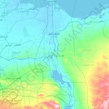
Nome: Mappa topografica Suez Canal, altitudine, rilievo.
Luogo: Suez Canal, Port Said, 43522, Egypt (29.93034 32.30378 31.27571 32.58750)
Altitudine media: 106 m
Altitudine minima: -6 m
Altitudine massima: 869 m
Although the alleged difference in sea levels could be problematic for construction, the idea of finding a shorter route to the east remained alive. In 1830, F. R. Chesney submitted a report to the British government that stated that there was no difference in elevation and that the Suez Canal was feasible, but his report received no further attention. Lieutenant Waghorn established his "Overland Route", which transported post and passengers to India via Egypt.
Altre mappe topografiche
Clicca su una mappa per visualizzarne la topografia, l'altitudine e il rilievo.
Al-ʿAbbāsiyyah Canal
Al-ʿAbbāsiyyah Canal, Port Said, 41524, Egypt
Altitudine media: 16 m