
Mappa topografica Toddville
Mappa interattiva
Clicca sulla mappa per visualizzare l'altitudine.
A proposito di questa mappa
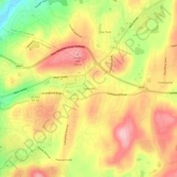
Nome: Mappa topografica Toddville, altitudine, rilievo.
Altitudine media: 114 m
Altitudine minima: 4 m
Altitudine massima: 193 m
Altre mappe topografiche
Clicca su una mappa per visualizzarne la topografia, l'altitudine e il rilievo.
Crompond
United States > New York > Westchester County > Town of Cortlandt
Crompond, Town of Cortlandt, Westchester County, New York, 10517, United States
Altitudine media: 131 m
Roe Park
United States > New York > Westchester County > Town of Cortlandt
Roe Park, Town of Cortlandt, Westchester County, New York, 10567, United States
Altitudine media: 106 m
Pleasantside
United States > New York > Westchester County > Town of Cortlandt
Pleasantside, Town of Cortlandt, Westchester County, New York, 10567, United States
Altitudine media: 108 m
Village of Croton-on-Hudson
United States > New York > Westchester County > Town of Cortlandt
Village of Croton-on-Hudson, Town of Cortlandt, Westchester County, New York, 10520, United States
Altitudine media: 42 m
Crugers
United States > New York > Westchester County > Town of Cortlandt
Crugers, Town of Cortlandt, Westchester County, New York, 10521, United States
Altitudine media: 23 m
Village of Buchanan
United States > New York > Westchester County > Town of Cortlandt
Village of Buchanan, Town of Cortlandt, Westchester County, New York, 10511, United States
Altitudine media: 28 m