
Fai una donazione
Preparati per la tua prossima avventura:
In qualità di associato Amazon, questo sito riceve una commissione sugli acquisti idonei senza alcun costo aggiuntivo per te.
Mappa topografica Suncook
Clicca sulla mappa per visualizzare l'altitudine.
Fai una donazione
Preparati per la tua prossima avventura:
In qualità di associato Amazon, questo sito riceve una commissione sugli acquisti idonei senza alcun costo aggiuntivo per te.
A proposito di questa mappa
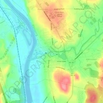
Nome: Mappa topografica Suncook, altitudine, rilievo.
Altitudine media: 93 m
Altitudine minima: 53 m
Altitudine massima: 155 m
Fai una donazione
Preparati per la tua prossima avventura:
In qualità di associato Amazon, questo sito riceve una commissione sugli acquisti idonei senza alcun costo aggiuntivo per te.
Altre mappe topografiche
Clicca su una mappa per visualizzarne la topografia, l'altitudine e il rilievo.
Sutton
United States > New Hampshire > Merrimack County
Sutton is a town in Merrimack County, New Hampshire, United States. The population was 1,978 at the 2020 census. Sutton includes the villages of Sutton Mills (shown as "Sutton" on topographic maps), North Sutton, South Sutton and East Sutton. North Sutton is home to Wadleigh State Park on Kezar Lake.
Altitudine media: 327 m
Pembroke
United States > New Hampshire > Merrimack County
According to the United States Census Bureau, the town has a total area of 22.8 square miles (59.1 km2), of which 22.6 square miles (58.6 km2) are land and 0.2 square miles (0.5 km2) are water, comprising 0.76% of the town. Pembroke is drained by the Merrimack River and its tributaries, the Suncook and the…
Altitudine media: 131 m
Boscawen
United States > New Hampshire > Merrimack County
According to the United States Census Bureau, the town has a total area of 25.5 square miles (66.1 km2), of which 24.9 square miles (64.5 km2) are land and 0.66 square miles (1.7 km2) are water, comprising 2.50% of the town. The highest point in Boscawen is an unnamed summit at Raleigh Farm near the town's…
Altitudine media: 157 m
Fai una donazione
Preparati per la tua prossima avventura:
In qualità di associato Amazon, questo sito riceve una commissione sugli acquisti idonei senza alcun costo aggiuntivo per te.
Wilmot
United States > New Hampshire > Merrimack County
Mount Kearsarge, elevation 2,931 feet (893 m) above sea level, on the southern border, is the highest point in town and in Merrimack County. Winslow State Park, at the northern foot of the mountain, provides access by two hiking trails to the summit. The state park and the Winslow Trail are named after Captain…
Altitudine media: 364 m
Warner
United States > New Hampshire > Merrimack County
Mount Kearsarge, elevation 2,937 feet (895 m) above sea level, located in the extreme north of the town, is the highest point in Warner. Two state parks are located on the mountain: Rollins State Park in Warner and Winslow State Park in Wilmot. Mount Kearsarge is a popular hiking destination, due both to its…
Altitudine media: 247 m
Fai una donazione
Preparati per la tua prossima avventura:
In qualità di associato Amazon, questo sito riceve una commissione sugli acquisti idonei senza alcun costo aggiuntivo per te.