
Fai una donazione
Preparati per la tua prossima avventura:
In qualità di associato Amazon, questo sito riceve una commissione sugli acquisti idonei senza alcun costo aggiuntivo per te.
Mappa topografica Waiouru
Clicca sulla mappa per visualizzare l'altitudine.
Fai una donazione
Preparati per la tua prossima avventura:
In qualità di associato Amazon, questo sito riceve una commissione sugli acquisti idonei senza alcun costo aggiuntivo per te.
Waiouru
Because of its high altitude and close proximity to Mt Ruapehu, Waiouru's climate is cold throughout the year, unlike other North Island centres, and particularly cold when the wind blows from the mountain. The Desert Road is regularly closed in winter owing to heavy snowfalls. Waiouru's climate can be described as continental.
Fai una donazione
Preparati per la tua prossima avventura:
In qualità di associato Amazon, questo sito riceve una commissione sugli acquisti idonei senza alcun costo aggiuntivo per te.
A proposito di questa mappa
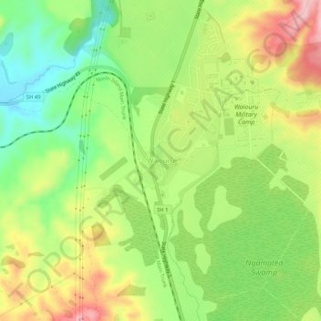
Nome: Mappa topografica Waiouru, altitudine, rilievo.
Altitudine media: 817 m
Altitudine minima: 727 m
Altitudine massima: 929 m
Fai una donazione
Preparati per la tua prossima avventura:
In qualità di associato Amazon, questo sito riceve una commissione sugli acquisti idonei senza alcun costo aggiuntivo per te.
Altre mappe topografiche
Clicca su una mappa per visualizzarne la topografia, l'altitudine e il rilievo.
Ohakune
New Zealand > Manawatu-Whanganui > Ruapehu District
Ohakune is located in the Ruapehu District and the Manawatū-Whanganui region, to the immediate south-west of the slopes of the Mount Ruapehu stratovolcano. The associated Ohakune volcanic complex is just to the north of the town and the small maar lakes Rangatauanui and Rangatauaiti are to the south of the…
Altitudine media: 595 m
Waiouru
New Zealand > Manawatu-Whanganui > Ruapehu District
Waiouru's climate is mild, with very little temperature variation from month to month throughout the year, but because of its high altitude and close proximity to Mt Ruapehu it is still relatively cool compared to other North Island population centres, and can get quite cold at anytime of the year when the…
Altitudine media: 814 m
Fai una donazione
Preparati per la tua prossima avventura:
In qualità di associato Amazon, questo sito riceve una commissione sugli acquisti idonei senza alcun costo aggiuntivo per te.
Tongariro National Park
New Zealand > Manawatu-Whanganui > Ruapehu District
The first development in the young Tongariro National Park was the construction of tourist huts at the beginning of the 20th century, but it was not until the opening of the North Island Main Trunk railway line between Auckland and Wellington in 1908 and the building of roads in the 1920s that a significant…
Altitudine media: 888 m
Fai una donazione
Preparati per la tua prossima avventura:
In qualità di associato Amazon, questo sito riceve una commissione sugli acquisti idonei senza alcun costo aggiuntivo per te.
Te Onetapu / Rangipo Desert
New Zealand > Manawatu-Whanganui > Ruapehu District
Much of the desert lies at an altitude of over 600 m (2,000 ft), and a considerable proportion of it is over 1,000 m (3,300 ft) above sea level. Many of the North Island's largest rivers have their headwaters in the area, particularly around the slopes of Mount Ruapehu, the North Island's highest mountain.…
Altitudine media: 1.015 m
Tongariro National Park
New Zealand > Manawatu-Whanganui > Ruapehu District
Like the whole of New Zealand, Tongariro National Park is situated in a temperate zone. The prevailing westerly winds gather water over the Tasman Sea. As the volcanoes of Tongariro National Park are the first significant elevations that these winds encounter on the North Island, besides Mount Taranaki, rain…
Altitudine media: 888 m