
Mappa topografica Bethlehem
Mappa interattiva
Clicca sulla mappa per visualizzare l'altitudine.
A proposito di questa mappa
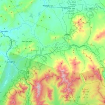
Nome: Mappa topografica Bethlehem, altitudine, rilievo.
Altitudine media: 528 m
Altitudine minima: 183 m
Altitudine massima: 1.572 m
According to the United States Census Bureau, the town has a total area of 91.0 square miles (235.7 km2), of which 90.6 square miles (234.7 km2) is land and 0.3 square miles (0.8 km2) is water, comprising 0.39% of the town. Bethlehem is drained by the Ammonoosuc, Gale, Zealand and Little rivers, together with Tuttle, Baker and Haystack brooks. Mount Cleveland, elevation 2,397 feet (731 m), and Mount Agassiz, 2,378 ft (725 m), rise to the south of the center of town. Town boundaries contain several of the famous 4,000-footers of New Hampshire: North Twin Mountain (the highest point in Bethlehem at 4,761 ft (1,451 m)), Mount Hale, Mount Tom, Mount Field and Mount Willey. Bethlehem lies almost fully within the Connecticut River watershed, though a tiny portion of the southeast corner of the town is in the Merrimack River watershed.
Altre mappe topografiche
Clicca su una mappa per visualizzarne la topografia, l'altitudine e il rilievo.
Mount Agassiz
United States > New Hampshire > Grafton County > Bethlehem
Mount Agassiz, Bethlehem, Grafton County, New Hampshire, 03574, United States
Altitudine media: 558 m