
Fai una donazione
Preparati per la tua prossima avventura:
In qualità di associato Amazon, questo sito riceve una commissione sugli acquisti idonei senza alcun costo aggiuntivo per te.
Mappa topografica Eagles Nest
Clicca sulla mappa per visualizzare l'altitudine.
Fai una donazione
Preparati per la tua prossima avventura:
In qualità di associato Amazon, questo sito riceve una commissione sugli acquisti idonei senza alcun costo aggiuntivo per te.
A proposito di questa mappa
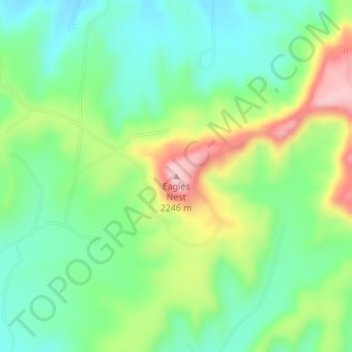
Nome: Mappa topografica Eagles Nest, altitudine, rilievo.
Luogo: Eagles Nest, Rio Arriba County, New Mexico, United States (36.40107 -107.33454 36.40117 -107.33444)
Altitudine media: 2.116 m
Altitudine minima: 2.044 m
Altitudine massima: 2.249 m
Fai una donazione
Preparati per la tua prossima avventura:
In qualità di associato Amazon, questo sito riceve una commissione sugli acquisti idonei senza alcun costo aggiuntivo per te.
Altre mappe topografiche
Clicca su una mappa per visualizzarne la topografia, l'altitudine e il rilievo.
Espanola
United States > New Mexico > Rio Arriba County
Española lies at an elevation of around 5,595 feet (1,705 m) with much variance. It is in a valley nestled between the Jemez and Sangre de Cristo mountain ranges, and the meeting point of three rivers, the Rio Grande, the Rio Chama, and the Rio Santa Cruz.
Altitudine media: 1.739 m
Dulce
United States > New Mexico > Rio Arriba County
Dulce is the southernmost urban area with a subarctic humid continental climate in North America (Köppen: Dfc) where summer is mild and short due to high altitude and rigorous winter. Going further south than the Dfb in low altitude and in latitude similar to the southern limit of the Dfa in the center of the…
Altitudine media: 2.179 m
Fai una donazione
Preparati per la tua prossima avventura:
In qualità di associato Amazon, questo sito riceve una commissione sugli acquisti idonei senza alcun costo aggiuntivo per te.
Espanola
United States > New Mexico > Rio Arriba County
Española lies at an elevation of around 5,595 feet (1,705 m) with much variance. It is in a valley nestled between the Jemez and Sangre de Cristo mountain ranges, and the meeting point of three rivers, the Rio Grande, the Rio Chama, and the Rio Santa Cruz.
Altitudine media: 1.739 m
Tierra Amarilla
United States > New Mexico > Rio Arriba County > Tierra Amarilla
Altitudine media: 2.290 m
Espanola
United States > New Mexico > Rio Arriba County
Española lies at an elevation of around 5,595 feet (1,705 m) with much variance. It is in a valley nestled between the Jemez and Sangre de Cristo mountain ranges, and the meeting point of three rivers, the Rio Grande, the Rio Chama, and the Rio Santa Cruz.
Altitudine media: 1.739 m