
Fai una donazione
Preparati per la tua prossima avventura:
In qualità di associato Amazon, questo sito riceve una commissione sugli acquisti idonei senza alcun costo aggiuntivo per te.
Mappa topografica Silver Falls
Clicca sulla mappa per visualizzare l'altitudine.
Fai una donazione
Preparati per la tua prossima avventura:
In qualità di associato Amazon, questo sito riceve una commissione sugli acquisti idonei senza alcun costo aggiuntivo per te.
A proposito di questa mappa
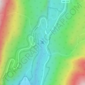
Nome: Mappa topografica Silver Falls, altitudine, rilievo.
Luogo: Silver Falls, Lewis County, Washington, United States (46.75228 -121.55954 46.75238 -121.55944)
Altitudine media: 847 m
Altitudine minima: 602 m
Altitudine massima: 1.348 m
Fai una donazione
Preparati per la tua prossima avventura:
In qualità di associato Amazon, questo sito riceve una commissione sugli acquisti idonei senza alcun costo aggiuntivo per te.
Altre mappe topografiche
Clicca su una mappa per visualizzarne la topografia, l'altitudine e il rilievo.
Winlock
United States > Washington > Lewis County
The eastern edge of the Willapa Hills lie to the west. To the east are relatively flat prairies. A notable landmark about four miles west of town is Sam Henry Mountain, elevation 1,492 feet (455 m), named for an early section superintendent of the Northern Pacific Railroad. Mt. St. Helens, about forty miles…
Altitudine media: 124 m
Fai una donazione
Preparati per la tua prossima avventura:
In qualità di associato Amazon, questo sito riceve una commissione sugli acquisti idonei senza alcun costo aggiuntivo per te.
Fai una donazione
Preparati per la tua prossima avventura:
In qualità di associato Amazon, questo sito riceve una commissione sugli acquisti idonei senza alcun costo aggiuntivo per te.
Fai una donazione
Preparati per la tua prossima avventura:
In qualità di associato Amazon, questo sito riceve una commissione sugli acquisti idonei senza alcun costo aggiuntivo per te.
Napavine
United States > Washington > Lewis County
A railroad depot was built in the late 1910s and provided passenger service until 1960. The Napavine Depot continued to serve the area until the station was permanently closed in April 1968 despite local protest. The Northern Pacific Railway station marked the highest elevation on the line between Portland and…
Altitudine media: 105 m