
Fai una donazione
Preparati per la tua prossima avventura:
In qualità di associato Amazon, questo sito riceve una commissione sugli acquisti idonei senza alcun costo aggiuntivo per te.
Mappa topografica Daulat Beg Oldi
Clicca sulla mappa per visualizzare l'altitudine.
Fai una donazione
Preparati per la tua prossima avventura:
In qualità di associato Amazon, questo sito riceve una commissione sugli acquisti idonei senza alcun costo aggiuntivo per te.
Daulat Beg Oldi
Daulat Beg Oldi (DBO) lies at the northeastern corner of the Karakoram Range, at the northern edge of Depsang Plains at an elevation of 5,100 metres (16,700 ft). The international border with China is 8 km to the north and the Line of Actual Control with Chinese-controlled Aksai Chin is 9 km to the east. Other than Siachen Glacier military bases, DBO is India's northernmost settlement. The nearest civilian town is Murgo to the south, which has a small population of Baltis.
Fai una donazione
Preparati per la tua prossima avventura:
In qualità di associato Amazon, questo sito riceve una commissione sugli acquisti idonei senza alcun costo aggiuntivo per te.
A proposito di questa mappa
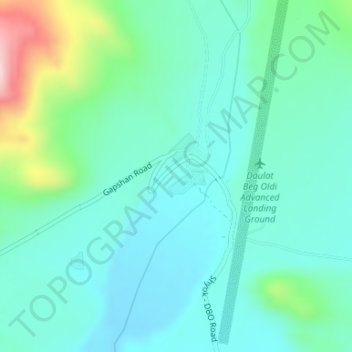
Nome: Mappa topografica Daulat Beg Oldi, altitudine, rilievo.
Luogo: Daulat Beg Oldi, Nubra district, Ladakh, India (35.38144 77.91114 35.40144 77.93114)
Altitudine media: 5.085 m
Altitudine minima: 5.025 m
Altitudine massima: 5.303 m
Fai una donazione
Preparati per la tua prossima avventura:
In qualità di associato Amazon, questo sito riceve una commissione sugli acquisti idonei senza alcun costo aggiuntivo per te.
Altre mappe topografiche
Clicca su una mappa per visualizzarne la topografia, l'altitudine e il rilievo.
Nubra
The main road access to Nubra is over Khardung La pass which is open throughout the year. The highest elevation of Khardung La is 5,359 m (17,582 ft), its status as the highest motorable road in the world is no longer accepted by most authorities. An alternative route, opened in 2008, crosses the Wari La from…
Altitudine media: 4.978 m
Leh district
Leh is connected to the rest of India by two high-altitude roads both of which are subject to landslides and neither of which are passable in winter when covered by deep snows. The National Highway 1D from Srinagar via Kargil is generally open longer. The Leh-Manali Highway can be troublesome due to very high…
Altitudine media: 4.974 m
Fai una donazione
Preparati per la tua prossima avventura:
In qualità di associato Amazon, questo sito riceve una commissione sugli acquisti idonei senza alcun costo aggiuntivo per te.
Kargil district old
Kargil has an average elevation of 2,676 metres (8,780 feet), and is situated along the banks of the Suru River (Indus). The town of Kargil is located 205 km (127 mi) from Srinagar, facing the Northern Areas across the LOC. Like other areas in the Himalayas, Kargil has a temperate climate. Summers are hot with…
Altitudine media: 4.214 m
Drang Drung Glacier
India > Ladakh > Zanskar tehsil
The Drang-Drung Glacier is likely to be the largest glacier in Ladakh after the Siachen Glacier in the Karakoram Range, with a maximum length of 23 km (14 mi) at an average elevation of 4,780 m (15,680 ft; 2.97 mi). The glacier lies in the northeastern Himalayan Range known as the Zanskar Range, 142 km (88 mi)…
Altitudine media: 5.098 m
Fai una donazione
Preparati per la tua prossima avventura:
In qualità di associato Amazon, questo sito riceve una commissione sugli acquisti idonei senza alcun costo aggiuntivo per te.
Zanskar
Zanskar covers an area of some 7,000 square kilometres (2,700 sq mi), generally at an elevation between 3,600 and 4,000 m (11,800 and 13,100 ft). It consists of the country lying along the two main branches of the Zanskar River. The first, the Doda River, has its source near the Pensi La 4,400 metres (14,400…
Altitudine media: 4.764 m
Fai una donazione
Preparati per la tua prossima avventura:
In qualità di associato Amazon, questo sito riceve una commissione sugli acquisti idonei senza alcun costo aggiuntivo per te.
Zanskar
Zanskar covers an area of some 7,000 square kilometres (2,700 sq mi), generally at an elevation between 3,600 and 4,000 m (11,800 and 13,100 ft). It consists of the country lying along the two main branches of the Zanskar River. The first, the Doda River, has its source near the Penzi La 4,400 metres (14,400…
Altitudine media: 4.764 m
Drang Drung Glacier
The Drang-Drung Glacier is likely to be the largest glacier in Ladakh after the Siachen Glacier in the Karakoram Range, with a maximum length of 23 km (14 mi) at an average elevation of 4,780 m (15,680 ft; 2.97 mi). The glacier lies in the northeastern Himalayan Range known as the Zanskar Range, 142 km (88 mi)…
Altitudine media: 5.101 m
Fai una donazione
Preparati per la tua prossima avventura:
In qualità di associato Amazon, questo sito riceve una commissione sugli acquisti idonei senza alcun costo aggiuntivo per te.
Kargil district old
Kargil has an average elevation of 2,676 metres (8,780 feet), and is situated along the banks of the Suru River (Indus). The town of Kargil is located 205 km (127 mi) from Srinagar, facing the Northern Areas across the LOC. Like other areas in the Himalayas, Kargil has a temperate climate. Summers are hot with…
Altitudine media: 4.214 m
Nubra district
One of the main draws of Nubra is the Khardongla pass, the highest motorable road at 18,380 feet, along with stunning peaks, glaciers, enchanting valleys, and villages. Diskit and Samstanling Monastery, Panamik thermal spring, two-humped camel ride, white-water rafting, hiking, and relaxing in the sand dunes…
Altitudine media: 4.978 m