
Mappa topografica River Ver
Clicca sulla mappa per visualizzare l'altitudine.
A proposito di questa mappa
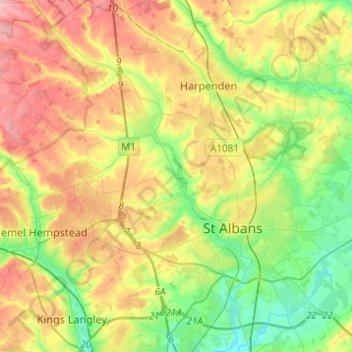
Nome: Mappa topografica River Ver, altitudine, rilievo.
Luogo: River Ver, St Albans, Hertfordshire, England, United Kingdom (51.69940 -0.48471 51.85143 -0.32463)
Altitudine media: 115 m
Altitudine minima: 60 m
Altitudine massima: 188 m
Altre mappe topografiche
Clicca su una mappa per visualizzarne la topografia, l'altitudine e il rilievo.
St Albans
United Kingdom > England > Hertfordshire > St Albans
St Albans was an ancient borough created following the dissolution of the monastery in 1539. It consisted of the ancient parish of St Albans (also known as the Abbey parish) and parts of St Michael and St Peter. The municipal corporation was reformed by the Municipal Corporations Act 1835 and the boundary was…
Altitudine media: 100 m
Highfield Park
United Kingdom > England > Hertfordshire > St Albans > Colney Heath
Altitudine media: 87 m
Blackmore End
United Kingdom > England > Hertfordshire > St Albans > Wheathampstead
Altitudine media: 114 m
Lower Gustard Wood
United Kingdom > England > Hertfordshire > St Albans > Wheathampstead
Altitudine media: 112 m
Tyttenhanger
United Kingdom > England > Hertfordshire > St Albans > Colney Heath
Altitudine media: 83 m
Napsbury Park
United Kingdom > England > Hertfordshire > St Albans > London Colney
Altitudine media: 78 m