
Mappa topografica Lebanon
Mappa interattiva
Clicca sulla mappa per visualizzare l'altitudine.
A proposito di questa mappa
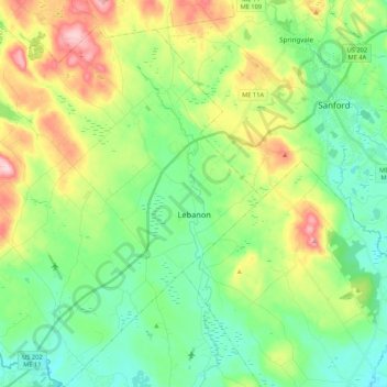
Nome: Mappa topografica Lebanon, altitudine, rilievo.
Luogo: Lebanon, York County, Maine, 04027, United States (43.32569 -70.98843 43.48059 -70.81347)
Altitudine media: 121 m
Altitudine minima: 51 m
Altitudine massima: 267 m
According to the United States Census Bureau, the town has a total area of 55.83 square miles (144.60 km2), of which, 55.00 square miles (142.45 km2) of it is land and 0.83 square miles (2.15 km2) is water. Lebanon is drained by the Little River and Salmon Falls River. The town's highest point is Prospect Hill, 880 feet (268 m) above sea level. The lowest elevation borders the Salmon Falls River, on the town's southernmost boundary, which is approximately 170 feet (52 m) above sea level.