

Mappa topografica Oldham
Clicca sulla mappa per visualizzare l'altitudine.
Oldham
By 1756, Oldham had emerged as centre of the hatting industry in England. The rough felt used in the production process is the origin of the term "Owdham Roughyed" a nickname for people from Oldham. It was not until the last quarter of the 18th century that Oldham changed from being a cottage industry township producing woollen garments via domestic manual labour, to a sprawling industrial metropolis of textile factories. The climate, geology, and topography of Oldham were unrelenting constraints upon the social and economic activities of the human inhabitants. At 700 feet (200 m) above sea level and with no major river or visible natural resources, Oldham had poor geographic attributes compared with other settlements for investors and their engineers. As a result, Oldham played no part in the initial period of the Industrial Revolution, although it did later become seen as obvious territory to industrialise because of its convenient position between the labour forces of Manchester and southwest Yorkshire.
A proposito di questa mappa
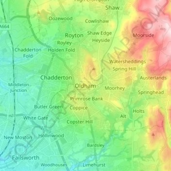
Nome: Mappa topografica Oldham, altitudine, rilievo.
Luogo: Oldham, Greater Manchester, England, OL1 1HE, United Kingdom (53.50158 -2.15478 53.58158 -2.07478)
Altitudine media: 173 m
Altitudine minima: 77 m
Altitudine massima: 375 m