
Mappa topografica High Point
Mappa interattiva
Clicca sulla mappa per visualizzare l'altitudine.
A proposito di questa mappa
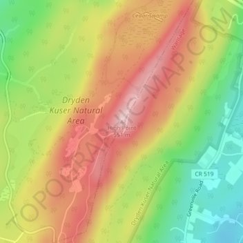
Nome: Mappa topografica High Point, altitudine, rilievo.
Altitudine media: 415 m
Altitudine minima: 283 m
Altitudine massima: 536 m
High Point is a mountain peak within High Point State Park on the border of Wantage Township and Montague Township, Sussex County, New Jersey. Located in the portion of the state known as the Skylands, it is the highest elevation in the state, with a peak elevation of 1,803 feet (550 m). The closest city is Port Jervis, New York, which lies to the northwest. Besides being the highest peak in New Jersey, High Point is also the highest peak of the Kittatinny Mountains. Three states – New Jersey, New York, and Pennsylvania – can be seen from the summit.