
Mappa topografica Sca Fell
Mappa interattiva
Clicca sulla mappa per visualizzare l'altitudine.
A proposito di questa mappa
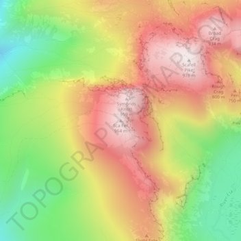
Nome: Mappa topografica Sca Fell, altitudine, rilievo.
Altitudine media: 619 m
Altitudine minima: 226 m
Altitudine massima: 970 m
The route from Scafell Pike to Scafell (or its reverse) is one of the most frustrating in the Lake District. What seems like a direct route is in fact very hazardous as it has to negotiate Broad Stand crag, which is a dangerous and exposed scramble that has caused many accidents and injuries. It is usually treated as a rock climb, with appropriate ropes and belay protection. Wainwright warns against its dangers to walkers. Its dangers are more obvious travelling from Scafell Pike, but travelling from Scafell, the route loses a lot of height before the danger is seen. Instead there are two walking routes, but they entail some loss of altitude. The first is via Foxes Tarn to the East of Scafell summit, and the second is via Lord's Rake and the West Wall traverse. All routes go via Mickledore.
Altre mappe topografiche
Clicca su una mappa per visualizzarne la topografia, l'altitudine e il rilievo.
Redhills Quarry (disused, flooded)
United Kingdom > England > Cumbria > Borough of Copeland > Millom > Rottington
Redhills Quarry (disused, flooded), Rottington, Millom, Borough of Copeland, Cumbria, England, United Kingdom
Altitudine media: 6 m
Mosedale
United Kingdom > England > Cumbria > Borough of Copeland
Mosedale, Wasdale, Borough of Copeland, Cumbria, England, CA20 1EX, United Kingdom
Altitudine media: 405 m
Distington
United Kingdom > England > Cumbria > Borough of Copeland
Distington, Borough of Copeland, Cumbria, England, United Kingdom
Altitudine media: 130 m
Ravenglass
United Kingdom > England > Cumbria > Borough of Copeland
Ravenglass, Borough of Copeland, Cumbria, England, CA18 1SE, United Kingdom
Altitudine media: 21 m
Blea Tarn
United Kingdom > England > Cumbria > Borough of Copeland > Boot > Beckfoot
Blea Tarn, Beckfoot, Eskdale, Boot, Borough of Copeland, Cumbria, England, United Kingdom
Altitudine media: 144 m
Bigrigg
United Kingdom > England > Cumbria > Borough of Copeland
Bigrigg, Borough of Copeland, Cumbria, England, CA22 2TJ, United Kingdom
Altitudine media: 75 m