
Fai una donazione
Preparati per la tua prossima avventura:
In qualità di associato Amazon, questo sito riceve una commissione sugli acquisti idonei senza alcun costo aggiuntivo per te.
Mappa topografica Viropa
Clicca sulla mappa per visualizzare l'altitudine.
Fai una donazione
Preparati per la tua prossima avventura:
In qualità di associato Amazon, questo sito riceve una commissione sugli acquisti idonei senza alcun costo aggiuntivo per te.
A proposito di questa mappa
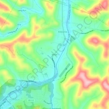
Nome: Mappa topografica Viropa, altitudine, rilievo.
Luogo: Viropa, Harrison County, West Virginia, 26568, United States (39.39194 -80.30155 39.43194 -80.26155)
Altitudine media: 333 m
Altitudine minima: 264 m
Altitudine massima: 456 m
Fai una donazione
Preparati per la tua prossima avventura:
In qualità di associato Amazon, questo sito riceve una commissione sugli acquisti idonei senza alcun costo aggiuntivo per te.
Altre mappe topografiche
Clicca su una mappa per visualizzarne la topografia, l'altitudine e il rilievo.
Fai una donazione
Preparati per la tua prossima avventura:
In qualità di associato Amazon, questo sito riceve una commissione sugli acquisti idonei senza alcun costo aggiuntivo per te.
Clarksburg
United States > West Virginia > Harrison County
Clarksburg had a humid continental climate if one considers the 0 °C isotherm. The latest temperature numbers have the climate as humid subtropical (Cfa). To the molds of Köppen the climate may be considered the southern boundary of the Dfb zone at low altitudes in the North American continent (limit of 39…
Altitudine media: 347 m
Fai una donazione
Preparati per la tua prossima avventura:
In qualità di associato Amazon, questo sito riceve una commissione sugli acquisti idonei senza alcun costo aggiuntivo per te.
Clarksburg
United States > West Virginia > Harrison County
Clarksburg is located at the junction of U.S. 50 and U.S. 19, two miles west of the junction of U.S. 50 with Interstate 79. The city lies at an elevation of 1,007 feet at the junction of Elk Creek and the West Fork River of the Monongahela River.
Altitudine media: 347 m
Fai una donazione
Preparati per la tua prossima avventura:
In qualità di associato Amazon, questo sito riceve una commissione sugli acquisti idonei senza alcun costo aggiuntivo per te.
Clarksburg City Park
United States > West Virginia > Harrison County > Nutter Fort
Altitudine media: 335 m