Geolocalizza

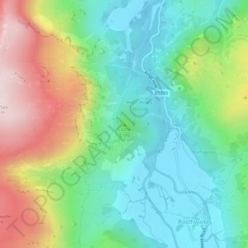
Mappa topografica Castle Crag

Clicca sulla mappa per visualizzare l'altitudine.

Castle Crag

The wooded height of Castle Crag rises between Broadslack Gill and the Derwent, the two streams meeting to the north beneath the outlying knoll of Low Hows. It has steep faces on all sides except the south, where a low ridge runs out and then swings west around the head of Broadslack Gill. A narrow col here provides the topographic link to High Spy.

Wikipedia (CC-BY-SA 3.0)

A proposito di questa mappa

Nome: Mappa topografica Castle Crag, altitudine, rilievo.

Luogo: Castle Crag, Borrowdale, Cumberland, England, CA12 5XA, United Kingdom (54.53313 -3.16156 54.53323 -3.16146)

Altitudine media: 272 m

Altitudine minima: 78 m

Altitudine massima: 647 m

Altre mappe topografiche

Clicca su una mappa per visualizzarne la topografia, l'altitudine e il rilievo.

Styhead Tarn

United Kingdom > England > Cumberland > Borrowdale

Altitudine media: 525 m

Preparati per la tua prossima avventura:

🧴Balsamo Labbra UV - Protezione specifica per le labbra contro sole e vento freddo
🚨Fischietti di Soccorso - Strumento di segnalazione acustica ad alta potenza per emergenze
🧦Calze in Lana Merino - Calze tecniche anti-vesciche per lunghe camminate in montagna
🧭Bussole di Precisione - Strumenti di navigazione affidabili per orientamento su mappe cartacee
🛏️Materassini campeggio - Isolamento e comfort notturno

In qualità di associato Amazon, questo sito riceve una commissione sugli acquisti idonei senza alcun costo aggiuntivo per te.