
Mappa topografica Avala
Mappa interattiva
Clicca sulla mappa per visualizzare l'altitudine.
A proposito di questa mappa
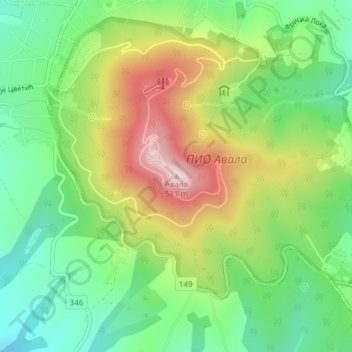
Nome: Mappa topografica Avala, altitudine, rilievo.
Altitudine media: 297 m
Altitudine minima: 162 m
Altitudine massima: 500 m
It is still debated whether Šuplja Stena is a natural cave or was completely dug for the mining purposes. Remains of the Neanderthal culture were discovered in it. In his 1943 Prehistoric mine Šuplja Stena on Avala hill near Belgrade (Serbia), Vladimir Milojčić said that the "cave is old as Avala", formed by the volcanic activity and elevation of the terrain. The cave was first used by the wild animals and later by the prehistoric peoples, with animal and human remains, and prehistoric mining artefacts have been discovered. However, geographer Dragan Petrović in his work on the caves of Šumadija, lists caves on the present Belgrade's territory, but makes no mention of Šuplja Stena.