
Fai una donazione
Preparati per la tua prossima avventura:
In qualità di associato Amazon, questo sito riceve una commissione sugli acquisti idonei senza alcun costo aggiuntivo per te.
Mappa topografica Barrington
Clicca sulla mappa per visualizzare l'altitudine.
Fai una donazione
Preparati per la tua prossima avventura:
In qualità di associato Amazon, questo sito riceve una commissione sugli acquisti idonei senza alcun costo aggiuntivo per te.
Barrington
Barrington lies on a low, mostly flat plain bordering the sea. This plain, composed mostly of layers of clay, gravel, sand, and silt soils, was formed by a melting glacier towards the end of the last ice age. Bedrock underlying the soil is largely composed of shales, sandstone, and conglomerate rock, with some outcrops of quartz. A few extremes in elevation, such as Nayatt Point, Primrose and Prince's Hill, rise to heights of fifty feet.
Fai una donazione
Preparati per la tua prossima avventura:
In qualità di associato Amazon, questo sito riceve una commissione sugli acquisti idonei senza alcun costo aggiuntivo per te.
A proposito di questa mappa
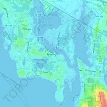
Nome: Mappa topografica Barrington, altitudine, rilievo.
Altitudine media: 4 m
Altitudine minima: -7 m
Altitudine massima: 47 m
Fai una donazione
Preparati per la tua prossima avventura:
In qualità di associato Amazon, questo sito riceve una commissione sugli acquisti idonei senza alcun costo aggiuntivo per te.
Altre mappe topografiche
Clicca su una mappa per visualizzarne la topografia, l'altitudine e il rilievo.
Fai una donazione
Preparati per la tua prossima avventura:
In qualità di associato Amazon, questo sito riceve una commissione sugli acquisti idonei senza alcun costo aggiuntivo per te.