
Mappa topografica Rileyville
Mappa interattiva
Clicca sulla mappa per visualizzare l'altitudine.
A proposito di questa mappa
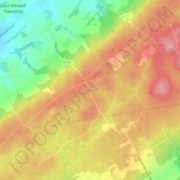
Nome: Mappa topografica Rileyville, altitudine, rilievo.
Altitudine media: 125 m
Altitudine minima: 54 m
Altitudine massima: 178 m
Altre mappe topografiche
Clicca su una mappa per visualizzarne la topografia, l'altitudine e il rilievo.
Linvale
United States > New Jersey > Hunterdon County > East Amwell Township
Linvale, East Amwell Township, Hunterdon County, New Jersey, United States
Altitudine media: 109 m
Bowne
United States > New Jersey > Hunterdon County > East Amwell Township
Bowne, East Amwell Township, Hunterdon County, New Jersey, United States
Altitudine media: 74 m
Larisons Corners
United States > New Jersey > Hunterdon County > East Amwell Township
Larisons Corners, East Amwell Township, Hunterdon County, New Jersey, 08551, United States
Altitudine media: 66 m
Snydertown
United States > New Jersey > Hunterdon County > East Amwell Township
Snydertown, East Amwell Township, Hunterdon County, New Jersey, 08551, United States
Altitudine media: 110 m
Wertsville
United States > New Jersey > Hunterdon County > East Amwell Township
Wertsville, East Amwell Township, Hunterdon County, New Jersey, United States
Altitudine media: 72 m
Ringoes
United States > New Jersey > Hunterdon County > East Amwell Township
Ringoes, East Amwell Township, Hunterdon County, New Jersey, 08551, United States
Altitudine media: 75 m