
Mappa topografica Novi Sad
Mappa interattiva
Clicca sulla mappa per visualizzare l'altitudine.
A proposito di questa mappa
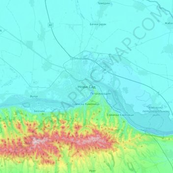
Nome: Mappa topografica Novi Sad, altitudine, rilievo.
Altitudine media: 135 m
Altitudine minima: 68 m
Altitudine massima: 538 m
The city lies on the meander of the river Danube, which is only 350 meters wide beneath the marking stones of Petrovaradin. A section of the Danube-Tisza-Danube Canal marks the northern edge of the wider city centre. The main part of the city lies on the left bank of the Danube in the region of Bačka, while the smaller settlements of Petrovaradin and Sremska Kamenica lie on the right bank, in the region of Srem (Syrmia). The section situated on the left bank of the river lies on one of the southernmost and lowest parts of the Pannonian Plain, while Fruška Gora on the right bank is a horst mountain. Alluvial plains along the Danube are well-formed, especially on the left bank, and in some parts 10 kilometres (6 miles) from the river. A large part of Novi Sad lies on a fluvial terrace with an elevation of between 80 and 83 metres (262 and 272 feet). The northern part of Fruška Gora is composed of massive landslide zones, although they are largely inactive with the exception of the Ribnjak neighbourhood between Sremska Kamenica and Petrovaradin Fortress. The total land area of the city is 699 square kilometres (270 sq mi), while its urban area spans 129.7 km2 (50 sq mi).
Altre mappe topografiche
Clicca su una mappa per visualizzarne la topografia, l'altitudine e il rilievo.
Backi Jarak
Serbia > Vojvodina > South Backa Administrative District > Temerin Municipality
Backi Jarak, Temerin Municipality, South Backa Administrative District, Vojvodina, 21234, Serbia
Altitudine media: 81 m
Fruška gora
Serbia > Vojvodina > South Backa Administrative District > Beocin Municipality
Fruška gora, Beocin Municipality, South Backa Administrative District, Vojvodina, 22212, Serbia
Altitudine media: 437 m
Backi Petrovac
Serbia > Vojvodina > South Backa Administrative District > Backi Petrovac Municipality
Backi Petrovac, Backi Petrovac Municipality, South Backa Administrative District, Vojvodina, 21470, Serbia
Altitudine media: 82 m
Bac Municipality
Serbia > Vojvodina > South Backa Administrative District
Bac Municipality, South Backa Administrative District, Vojvodina, Serbia
Altitudine media: 88 m
Нови Сад
Serbia > Vojvodina > South Backa Administrative District > Novi Sad City
Нови Сад, Novi Sad City, South Backa Administrative District, Vojvodina, Serbia
Altitudine media: 83 m
Ledinci
Serbia > Vojvodina > South Backa Administrative District
Ledinci, South Backa Administrative District, Vojvodina, 21207, Serbia
Altitudine media: 128 m
City of Novi Sad
Serbia > Vojvodina > South Backa Administrative District
City of Novi Sad, South Backa Administrative District, Vojvodina, Serbia
Altitudine media: 122 m
Sremski Karlovci
Serbia > Vojvodina > South Backa Administrative District > Sremski Karlovci Municipality > Sremski Karlovci
Sremski Karlovci, Sremski Karlovci Municipality, South Backa Administrative District, Vojvodina, 21205, Serbia
Altitudine media: 130 m
Becej
Serbia > Vojvodina > South Backa Administrative District > Becej Municipality
Becej, Becej Municipality, South Backa Administrative District, Vojvodina, 21220, Serbia
Altitudine media: 78 m
Sremska Kamenica
Serbia > Vojvodina > South Backa Administrative District > Novi Sad City > Sremska Kamenica
Sremska Kamenica, Novi Sad City, South Backa Administrative District, Vojvodina, 21208, Serbia
Altitudine media: 130 m