
Mappa topografica Village of Hamilton
Mappa interattiva
Clicca sulla mappa per visualizzare l'altitudine.
A proposito di questa mappa
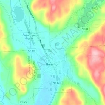
Nome: Mappa topografica Village of Hamilton, altitudine, rilievo.
Altitudine media: 386 m
Altitudine minima: 331 m
Altitudine massima: 502 m
The village, located at 42°49′32″N 75°32′40″W / 42.82556°N 75.54444°W / 42.82556; -75.54444 (42.825646, -75.544673), lies in the Chenango Valley, just south of the headwaters of the Chenango River. Northeast of the village is the river Payne Brook, which starts at Lake Moraine and travels through the village before converging with the Chenango River. The village is approximately 40 miles (64 km) southeast of Syracuse and 30 miles (48 km) southwest of Utica. The elevation of the village's municipal airport (Hamilton Municipal Airport) is approximately 1,100 feet (340 m) above sea level.
Altre mappe topografiche
Clicca su una mappa per visualizzarne la topografia, l'altitudine e il rilievo.
Village of Earlville
United States > New York > Madison County > Town of Hamilton
Village of Earlville, Town of Hamilton, Madison County, New York, United States
Altitudine media: 342 m