
Fai una donazione
Preparati per la tua prossima avventura:
In qualità di associato Amazon, questo sito riceve una commissione sugli acquisti idonei senza alcun costo aggiuntivo per te.
Mappa topografica Spring Hill
Clicca sulla mappa per visualizzare l'altitudine.
Fai una donazione
Preparati per la tua prossima avventura:
In qualità di associato Amazon, questo sito riceve una commissione sugli acquisti idonei senza alcun costo aggiuntivo per te.
Spring Hill
In 1856, James B. Hovey named the community after a town near Mobile, Alabama. "Being somewhat enthusiastic in my estimation of its future, it having all advantages of timber and water, and on a line that must be traveled between Olathe and Paola, I concluded to myself, as there was no one else to conclude with, that this was a good place for a town." – J.B. Hovey, 1857 Hovey served as the communities first postmaster. Also that year, Hovey built the first building in town, the Spring Hill Hotel. The two-story structure, also known as the "Old Traveler's Rest" was located on the highest elevation in town.
Fai una donazione
Preparati per la tua prossima avventura:
In qualità di associato Amazon, questo sito riceve una commissione sugli acquisti idonei senza alcun costo aggiuntivo per te.
A proposito di questa mappa
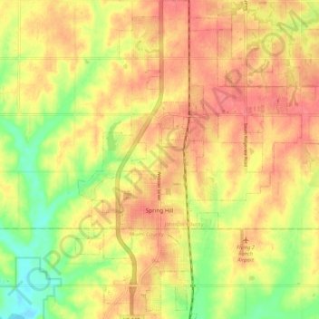
Nome: Mappa topografica Spring Hill, altitudine, rilievo.
Luogo: Spring Hill, Johnson County, Kansas, 66083, United States (38.71525 -94.85317 38.79665 -94.77897)
Altitudine media: 317 m
Altitudine minima: 279 m
Altitudine massima: 340 m
Fai una donazione
Preparati per la tua prossima avventura:
In qualità di associato Amazon, questo sito riceve una commissione sugli acquisti idonei senza alcun costo aggiuntivo per te.
Altre mappe topografiche
Clicca su una mappa per visualizzarne la topografia, l'altitudine e il rilievo.
Fai una donazione
Preparati per la tua prossima avventura:
In qualità di associato Amazon, questo sito riceve una commissione sugli acquisti idonei senza alcun costo aggiuntivo per te.