
Fai una donazione
Preparati per la tua prossima avventura:
In qualità di associato Amazon, questo sito riceve una commissione sugli acquisti idonei senza alcun costo aggiuntivo per te.
Mappa topografica Grand Isle
Clicca sulla mappa per visualizzare l'altitudine.
Fai una donazione
Preparati per la tua prossima avventura:
In qualità di associato Amazon, questo sito riceve una commissione sugli acquisti idonei senza alcun costo aggiuntivo per te.
Grand Isle
Chenier habitats are not limited to Grand Isle, but were historically found in wetlands throughout the southeastern coasts of Louisiana called the Chenier Plain. Today, the Chenier Plain consists of uplands, wetlands, and open water that extends from Vermillion Bay, Louisiana to East Bay, Texas. Of the original 500,000 acres (200,000 ha) that had existed, an estimated 5,000 to 10,000 square acres remain. Chenier forests consist of hardwood trees, primarily oaks and hackberries, as well as a variety of other vegetation such as mulberry, honeylocust, water oak, green ash, and American elm, all which grow along slightly elevated ridges. These ridges are the result of the build-up of sediment from periodic shifts of the Mississippi River's delta and can range in size from 1–3 metres (3.3–9.8 ft) high and between 30–450 metres (98–1,476 ft) wide. Because of the slightly higher elevation, chenier forests not only allow for the growth of hardwood trees that support the variety of migratory birds that pass through Grand Isle, but also act as a barrier for salt water intrusion into a marsh during storm surges. Typically, marshes that are north of a chenier are less saline than marshes that are closer to the gulf.
Fai una donazione
Preparati per la tua prossima avventura:
In qualità di associato Amazon, questo sito riceve una commissione sugli acquisti idonei senza alcun costo aggiuntivo per te.
A proposito di questa mappa
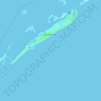
Nome: Mappa topografica Grand Isle, altitudine, rilievo.
Luogo: Grand Isle, Jefferson Parish, Louisiana, United States (29.16627 -90.09034 29.26789 -89.94949)
Altitudine media: 0 m
Altitudine minima: -2 m
Altitudine massima: 7 m
Fai una donazione
Preparati per la tua prossima avventura:
In qualità di associato Amazon, questo sito riceve una commissione sugli acquisti idonei senza alcun costo aggiuntivo per te.
Altre mappe topografiche
Clicca su una mappa per visualizzarne la topografia, l'altitudine e il rilievo.
Gretna
United States > Louisiana > Jefferson Parish > Gretna > Gretna
Gretna is located at 29°54′59″N 90°3′15″W / 29.91639°N 90.05417°W / 29.91639; -90.05417 (29.916459, -90.054260) and has an elevation of 0 feet (0 m) behind the levee along the Mississippi River.
Altitudine media: 2 m
Fai una donazione
Preparati per la tua prossima avventura:
In qualità di associato Amazon, questo sito riceve una commissione sugli acquisti idonei senza alcun costo aggiuntivo per te.