
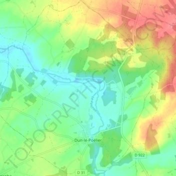
Mappa topografica Dun-le-Poëlier
Mappa interattiva
Clicca sulla mappa per visualizzare l'altitudine.
A proposito di questa mappa
Nome: Mappa topografica Dun-le-Poëlier, altitudine, rilievo.
Altitudine media: 112 m
Altitudine minima: 85 m
Altitudine massima: 155 m
Altre mappe topografiche
Clicca su una mappa per visualizzarne la topografia, l'altitudine e il rilievo.
Villiers
France > Centre-Val de Loire > Indre
Villiers, Le Blanc, Indre, Centre-Val de Loire, Metropolitan France, 36290, France
Altitudine media: 131 m
Roy
France > Centre-Val de Loire > Indre > Sainte-Gemme
Roy, Sainte-Gemme, Le Blanc, Indre, Centre-Val de Loire, Metropolitan France, 36500, France
Altitudine media: 104 m
Lacs
France > Centre-Val de Loire > Indre
Lacs, La Châtre, Indre, Centre-Val de Loire, Metropolitan France, 36400, France
Altitudine media: 224 m
Chavin
France > Centre-Val de Loire > Indre > Chavin
Chavin, Châteauroux, Indre, Centre-Val de Loire, Metropolitan France, 36200, France
Altitudine media: 230 m
Châteauroux
France > Centre-Val de Loire > Indre > Châteauroux
Châteauroux, Indre, Centre-Val de Loire, Metropolitan France, 36000, France
Altitudine media: 153 m
La Châtre
France > Centre-Val de Loire > Indre
La Châtre, Indre, Centre-Val de Loire, Metropolitan France, 36400, France
Altitudine media: 236 m