
Fai una donazione
Preparati per la tua prossima avventura:
In qualità di associato Amazon, questo sito riceve una commissione sugli acquisti idonei senza alcun costo aggiuntivo per te.
Mappa topografica Saint Paul Island
Clicca sulla mappa per visualizzare l'altitudine.
Fai una donazione
Preparati per la tua prossima avventura:
In qualità di associato Amazon, questo sito riceve una commissione sugli acquisti idonei senza alcun costo aggiuntivo per te.
Saint Paul Island
Saint Paul is the largest of the Pribilof Islands and lies the farthest north. With a width of 7.66 mi (12.33 km) at its widest point and a length of 13.5 mi (21.7 km) on its longest axis (which runs from northeast to southwest), it has a total area of 43 sq mi (110 km2). Volcanic in origin, Saint Paul features a number of cinder cones and volcanic craters in its interior. The highest of these, Rush Hill, rises to 665 ft (203 m) on the island's western shore, though most of the upland areas average less than 150 ft (46 m) in elevation. Most of the island is a low-lying mix of rocky plateaus and valleys, with some of the valleys holding freshwater ponds. Much of its 45.5 mi (73.2 km) of shoreline is rugged and rocky, rising to sheer cliffs at several headlands, though long sandy beaches backed by shifting sand dunes flank a number of shallow bays.
Fai una donazione
Preparati per la tua prossima avventura:
In qualità di associato Amazon, questo sito riceve una commissione sugli acquisti idonei senza alcun costo aggiuntivo per te.
A proposito di questa mappa
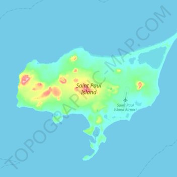
Nome: Mappa topografica Saint Paul Island, altitudine, rilievo.
Altitudine media: 10 m
Altitudine minima: 0 m
Altitudine massima: 192 m
Fai una donazione
Preparati per la tua prossima avventura:
In qualità di associato Amazon, questo sito riceve una commissione sugli acquisti idonei senza alcun costo aggiuntivo per te.
Altre mappe topografiche
Clicca su una mappa per visualizzarne la topografia, l'altitudine e il rilievo.