
Mappa topografica Addison (Webster Springs)
Mappa interattiva
Clicca sulla mappa per visualizzare l'altitudine.
A proposito di questa mappa
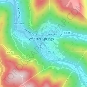
Nome: Mappa topografica Addison (Webster Springs), altitudine, rilievo.
Altitudine media: 600 m
Altitudine minima: 431 m
Altitudine massima: 878 m
Webster Springs is located at 38°28′34″N 80°24′36″W / 38.47611°N 80.41000°W / 38.47611; -80.41000 (38.476192, -80.410025), along the Elk River. According to the United States Census Bureau, the town has a total area of 0.47 square miles (1.22 km2), of which 0.45 square miles (1.17 km2) is land and 0.02 square miles (0.05 km2) is water. It lies at an elevation of 1,460 ft. (445m) and is close to Buffalo Bull Knob, elevation 2,799 ft.
Altre mappe topografiche
Clicca su una mappa per visualizzarne la topografia, l'altitudine e il rilievo.
Cowen
United States > West Virginia > Webster County
Cowen, Webster County, West Virginia, 26206, United States
Altitudine media: 709 m
Wheeler
United States > West Virginia > Webster County
Wheeler, Webster County, West Virginia, 26215, United States
Altitudine media: 547 m