
Fai una donazione
Preparati per la tua prossima avventura:
In qualità di associato Amazon, questo sito riceve una commissione sugli acquisti idonei senza alcun costo aggiuntivo per te.
Mappa topografica Saipan
Clicca sulla mappa per visualizzare l'altitudine.
Fai una donazione
Preparati per la tua prossima avventura:
In qualità di associato Amazon, questo sito riceve una commissione sugli acquisti idonei senza alcun costo aggiuntivo per te.
Saipan
Saipan, the largest island in the Northern Mariana Islands, features a diverse and rugged topography shaped by volcanic activity. The island's central region is dominated by Mount Tapochau, its highest peak at 1,553 feet (474 meters), providing a dramatic backdrop to the surrounding landscape. This volcanic terrain is primarily composed of andesitic and dacitic rocks, formed from the island’s volcanic origins. The eastern coastline is characterized by steep cliffs and rugged hills, while the western side presents more gradual slopes leading to coral reefs and sandy beaches. Saipan's geography is also marked by extensive limestone plateaus, particularly in the southern areas, and lush valleys with tropical vegetation. These varied landforms contribute to the island's distinctive natural beauty and its importance as a key location in the Pacific.
Fai una donazione
Preparati per la tua prossima avventura:
In qualità di associato Amazon, questo sito riceve una commissione sugli acquisti idonei senza alcun costo aggiuntivo per te.
A proposito di questa mappa
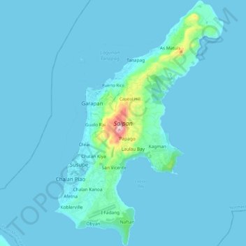
Nome: Mappa topografica Saipan, altitudine, rilievo.
Altitudine media: 22 m
Altitudine minima: 0 m
Altitudine massima: 462 m
Fai una donazione
Preparati per la tua prossima avventura:
In qualità di associato Amazon, questo sito riceve una commissione sugli acquisti idonei senza alcun costo aggiuntivo per te.