
Fai una donazione
Preparati per la tua prossima avventura:
In qualità di associato Amazon, questo sito riceve una commissione sugli acquisti idonei senza alcun costo aggiuntivo per te.
Mappa topografica Moosic
Clicca sulla mappa per visualizzare l'altitudine.
Fai una donazione
Preparati per la tua prossima avventura:
In qualità di associato Amazon, questo sito riceve una commissione sugli acquisti idonei senza alcun costo aggiuntivo per te.
Moosic
Moosic is located in the Wyoming Valley of northeastern Pennsylvania. In terms of physiography, Moosic is part of the Ridge and Valley province of the Appalachian Mountains. Moosic is located at an elevation of 817 feet (249 m) above sea level. The major body of water flowing through the borough is the Lackawanna River, part of the Upper Susquehanna-Lackawanna Watershed. Moosic has a total area of 6.6 square miles (17 km2), of which 6.5 square miles (17 km2) is land and 0.1 square miles (0.26 km2) (1.52%) is water. Moosic has a humid continental climate (Köppen Dfa) with four distinct seasons. Summers are humid and warm, with an occasional heatwave. Winters are cold and snowy.
Fai una donazione
Preparati per la tua prossima avventura:
In qualità di associato Amazon, questo sito riceve una commissione sugli acquisti idonei senza alcun costo aggiuntivo per te.
A proposito di questa mappa
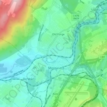
Nome: Mappa topografica Moosic, altitudine, rilievo.
Altitudine media: 246 m
Altitudine minima: 166 m
Altitudine massima: 505 m
Fai una donazione
Preparati per la tua prossima avventura:
In qualità di associato Amazon, questo sito riceve una commissione sugli acquisti idonei senza alcun costo aggiuntivo per te.
Altre mappe topografiche
Clicca su una mappa per visualizzarne la topografia, l'altitudine e il rilievo.
Mount Cobb
United States > Pennsylvania > Lackawanna County > Jefferson Township
Altitudine media: 529 m
Wimmers
United States > Pennsylvania > Lackawanna County > Jefferson Township > Mount Cobb
Altitudine media: 495 m
Fai una donazione
Preparati per la tua prossima avventura:
In qualità di associato Amazon, questo sito riceve una commissione sugli acquisti idonei senza alcun costo aggiuntivo per te.
Fai una donazione
Preparati per la tua prossima avventura:
In qualità di associato Amazon, questo sito riceve una commissione sugli acquisti idonei senza alcun costo aggiuntivo per te.
Eagle Lake
United States > Pennsylvania > Lackawanna County > Covington Township
Altitudine media: 578 m
Madisonville
United States > Pennsylvania > Lackawanna County > Madison Township
Altitudine media: 512 m
Falling Springs Reservoir
United States > Pennsylvania > Lackawanna County > Ransom Township
Altitudine media: 375 m
Fai una donazione
Preparati per la tua prossima avventura:
In qualità di associato Amazon, questo sito riceve una commissione sugli acquisti idonei senza alcun costo aggiuntivo per te.
Pine Hill Vista
United States > Pennsylvania > Lackawanna County > Thornhurst Township
Altitudine media: 628 m
Birchwood Estates
United States > Pennsylvania > Lackawanna County > Roaring Brook Township
Altitudine media: 512 m
Spring Brook
United States > Pennsylvania > Lackawanna County > Spring Brook Township
Altitudine media: 463 m
Fai una donazione
Preparati per la tua prossima avventura:
In qualità di associato Amazon, questo sito riceve una commissione sugli acquisti idonei senza alcun costo aggiuntivo per te.
Mount Cobb
United States > Pennsylvania > Lackawanna County > Jefferson Township
Altitudine media: 529 m
Fai una donazione
Preparati per la tua prossima avventura:
In qualità di associato Amazon, questo sito riceve una commissione sugli acquisti idonei senza alcun costo aggiuntivo per te.
Fai una donazione
Preparati per la tua prossima avventura:
In qualità di associato Amazon, questo sito riceve una commissione sugli acquisti idonei senza alcun costo aggiuntivo per te.