
Mappa topografica Krupanj
Mappa interattiva
Clicca sulla mappa per visualizzare l'altitudine.
A proposito di questa mappa
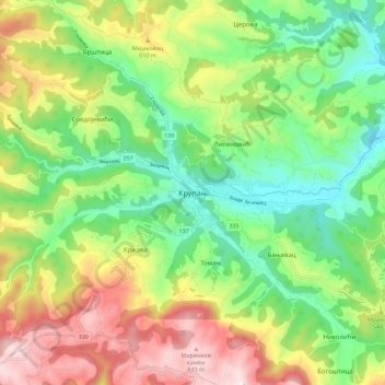
Nome: Mappa topografica Krupanj, altitudine, rilievo.
Altitudine media: 484 m
Altitudine minima: 229 m
Altitudine massima: 876 m
The town lies in western Serbia, at the southern border of the Pannonian plain and Mačva region. It is surrounded by the mountains Jagodnja, Boranja and Sokolska planina, in a valley intersected by several rivers and creeks. In the town itself, the rivers Bogoštica, Čađavica and Kržava conjoin into Likodra, which later empties into Jadar. The town lies at the altitude of 280 m.
Altre mappe topografiche
Clicca su una mappa per visualizzarne la topografia, l'altitudine e il rilievo.
Brezovice
Serbia > Central Serbia > Macva Administrative District > Krupanj Municipality
Brezovice, Krupanj Municipality, Macva Administrative District, Central Serbia, 15312, Serbia
Altitudine media: 240 m